By Adriana Kocornik-Mina, Guest researcher, Alterra – Wageningen UR; Thomas McDermott, Lecturer at the School of Economics and Principal Investigator at the Environmental Research Institute, University College Cork; Guy Michaels, Associate Professor in the Department of Economics, LSE; and Ferdinand Rauch, Associate Professor at the Department of Economics, University of Oxford. Originally published at VoxEU
During the past couple of months alone, floods have displaced 100,000 people or more in Kenya, in Paraguay and Uruguay, and in India, as well as more than 50,000 people in the UK. And rising sea levels due to climate change loom. This column assesses the risk and the challenges for policymakers. It details the effects of flooding in cities around the world, showing that economic activity is concentrated in low-elevation urban areas, despite their much greater exposure to flooding. And worryingly, economic activity tends to return to flood-prone low-lying areas rather than relocating.
Extreme rainfall during December 2015 resulted in widespread flooding across northern England, Scotland and Ireland. The cost of this particular period will potentially exceed $2 billion (Bounds 2015). An important policy question is therefore: Why are so many people hit by flooding, particularly in locations that are repeatedly inundated?
The recent events in the UK and Ireland are just one example of a major global problem. According to media reports collated by the Dartmouth Flood Observatory (2014), from 1985-2014 floods worldwide killed more than 500,000 people, displaced over 650,000,000 people, and caused damage in excess of $500 billion. Other datasets tell of even greater impacts – according to the International Disaster Database (EM-DAT, see Guha-Sapir et al. 2015), in 2010 alone 178 million people were affected by floods and total losses exceeded $40 billion. To these direct costs we should add longer-term costs due to the disruption of schools, increased health risks and disincentives to invest.
Imperative to understand
So it seems important to understand why so much is lost to floods. One might argue that the risks of floods are balanced by gains from living in flood-prone areas. But as Kydland and Prescott (1977) show, flood plains tend to be overpopulated, because the cost of building and maintaining flood defenses is often borne by governments and not by private developers. This problem is in fact worse than you might think, because the costs of flood recovery are also often borne by government and NGOs. This situation creates potential for misallocation of resources, and forces society to answer difficult distributional questions.
In a recent working paper (Kocornik-Mina et al. 2015), we examine how prevalent it is for economic activity to be concentrated in flood-prone areas, and whether cities adapt to major floods by relocating economic activity to safer areas.
Large-Scale Urban Floods
In our empirical analysis we study the impact of large-scale urban floods. We use new data from spatially disaggregated inundation maps of 53 large floods, which took place from 2003-2008. Each of these floods displaced at least 100,000 people, and taken together the floods affected 1,868 cities in 40 countries around the globe, mostly in developing countries. Figure 1 shows the locations of the large flood events included in our analysis. We study the local economic impact of the floods using satellite images of night-lights at an annual frequency.
Figure 1. Map showing the locations of world’s cities, including those affected by our sample of large flood events
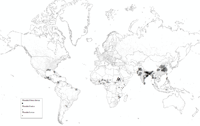
Notes: City sizes are inflated in order to make them visible on a map of the entire world. Smaller dots correspond to cities not affected by any of the floods in our sample. The number of floods in the legend refers to the number of years from 2003-2008 during which each city was affected by a flood that displaced a total of 100,000 people or more.
Our data show that the global exposure of urban areas to large-scale flooding is substantial, with low-lying urban areas flooded much more frequently. Globally, the average annual risk of a large flood hitting a city is about 1.3% for urban areas that are more than 10 metres above sea level, and 4.9% for urban areas at lower elevation. In other words, urban areas that are less than 10m above sea level face an average annual risk of about one in 20 of being hit by a large flood. Of course, this average masks considerable variation across locations. Local flooding risk results from a complex combination of local climate, permeation, and topography, among other factors. Some urban areas – even if located at low elevation – will flood rarely, if ever. At the other extreme, some urban areas flood repeatedly. In our sample, about 16% of the cities that are hit by large floods are flooded in multiple years.
We also find that even though low-lying areas are more likely to flooded, they concentrate a higher density of economic activity, as proxied by night-light intensity. This disproportionate concentration of economic activity in low elevation areas is found even for areas that are prone to extreme precipitation, where the risk of large scale flooding is highest.
When we analyse the local economic impact of large floods, we find that on average they reduce a city’s economic activity as measured by night time lights by between 2% and 8% in the year of the flood. Recovery, however, is relatively quick – lights typically recover fully within a year of a major flood, even in the hardest hit low-lying areas. This pattern of recovery is illustrated in Figure 2 for the case of Hurricane Katrina, which hit the city of New Orleans in 2005. We note, however, that New Orleans is unusual in our sample, because it is much richer (and much better lit) than most of the flooded cities.
Figure 2. Inundation and light intensity maps for Hurricane Katrina, New Orleans
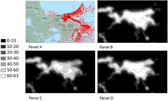
Notes: Panel A shows a detail from one of the inundation maps associated with Hurricane Katrina, concentrated on the area around the city of New Orleans. The map displays in red and pink the areas that were inundated during the flooding. Panels B, C and D show the average annual light intensity in 2004, 2005, 2006 respectively, for the city of New Orleans. There is a notable dimming of lights city-wide in 2005. In Panel D a recovery of light intensity is apparent.
Our finding that economic activity recovers after floods even in low-lying areas suggests that there is no significant adaptation, at least in the sense of a relocation of economic activity away from the most vulnerable locations. With economic activity fully restored in vulnerable locations, the scene is sadly set for the next round of flooding.
A possible motivation for restoring vulnerable locations is to take advantage of the trading opportunities – and amenity value – offered by waterside locations. But we find that economic activity is fully restored even in low-elevation locations that do not enjoy the offsetting advantages of being near a river or coast.
Our results are also robust to restricting our sample to cities with at least some areas more than 10 metres above sea level. This means that there is no movement to higher ground in the aftermath of large floods even within cities where such movement is possible.
Cities That Don’t Adapt
One exception to our general finding that cities do not adapt in response to large floods can be found in the subset of recently populated parts of cities (those that had no night lights in 1992). We find that in these recently populated urban areas, flooded areas show a larger and more persistent decline in night-light intensity, indicating a stronger relocation of economic activity in response to flooding. This may be because in these newer urban locations flood risk was under-appreciated and the floods led to updating, or it may be because these newer areas had fewer past investments, so moving away was less costly.
Conclusions
Our findings are important for a number of reasons.
• First, the trend towards increased urbanisation around the world, and especially in poor regions, is still ongoing. As urbanisation progresses, it is important to know whether cities adapt and their populations avoid dangerous areas. Our results suggest that flooding poses an important challenge for urban planning because adaptation away from flood-prone locations cannot be taken for granted, even in the aftermath of large and devastating floods.
• Second, floods disproportionately affect poor countries. Given the scale of human devastation and its potential to affect the formation of human capital (for example, disruptions to education or damage to people’s health), this is an important issue for growth and development. Specifically, planning and zoning laws and their enforcement are weak in developing countries. Consequently, slums and other informal urban settlements tend to develop on cheap land with poor infrastructure, which includes flood-prone land. More than 860 million people live in flood-prone urban areas worldwide. Annual increases of 6 million a year were observed between 2000 and 2010. Our finding that low-elevation areas concentrate much of the economic activity, even in poor urban areas with erratic weather patterns, highlights the tragedy of the recurring crisis imposed by flooding.
• Third, global warming, and especially rising sea levels, are expected to further exacerbate the problem of flooding in many of the world’s cities.
• Fourth, recovery assistance after flooding is an important part of international aid. Our findings suggest that in some circumstances, part of the aid and reconstruction efforts should be targeted at moving economic activity away from the most flood-prone areas, in order to mitigate the risk of recurrent humanitarian disasters.
• Finally, our results are relevant for discussions of the costly effects of path dependence (Bleakly and Lin 2012, Michaels and Rauch 2013). Our findings suggest that cities and the parts of cities that are built in flood-prone areas may be locking in exposure to flood risk for a long time.
See original post for references


Its a huge issue that in the end threatens all of humanity so by all means lets all jump on planes (flights are cheap and getting cheaper) fly all over the world on a regular basis and discuss the predicament.
This begs a question; Why do people return to the flooded regions century after century, after the deluge subsides? Why do the US, UK, and other well developed nations have extreme flooding and can’t find a way to do anything about them? (see question one)
I will offer a few possible answer among thousands. The “river” is the lifeblood of its region, the main highway for travel, the crops, the land, and nowhere else to go.
The people that live there also know that it will flood and they will be moved from the spot, even if temporarily, and that this is not unexpected.
Perhaps this is the same reason people prefer cities on the ocean? They don’t believe it will happen there.
Is this a matter of reason, or is it animal spirits?
Gross photosynthesis is highest at the interface.
Rivers bring nutrients, so the river outlets are usually good hunting. As settlements grew to cities, and trade became important, ports for shipping by water meant economies of scale and efficient transport. Some ancient cities are miles back from the current port due to siltation.
The rivers supply drinking water and sweep away sewage, important for dense populations. And floodplains, being plains, are flat and easy to colonize and build on.
the same reason that people will go back to the desert, or any place they were born, or lived for a long time. it was home.
Having experienced Katrina and the “recovery” from her first hand, I do notice the responsibility of local and regional State actors to ameliorate the risks. There seems to be no centralized planning extant for the Domestic effects of flooding. Zoning and insurance look to be the preferred methods of shaping the domestic long term response to incidents of flooding. America has a fairly good Federally backed Flood Insurance program. Now, some of the criteria are being grudgingly changed. In Coastal Mississippi, the premiums for flood insurance have risen significantly. A slow population shift from the Coast to the inland regions seems to be the desired result. Zoning requirements are tightening, and driving up the costs of living on the Coast for the denizens. I used to joke that this was an insidious “gentrification” program. Fair enough. However, I see no coordinated program from the State and Federal governments to plan for and co-ordinate the eventual relocation of the population and businesses in the flood zones to the inland. This smells like yet another “the Market will take care of everything” moment. No one will publically say, “No, the Market will not do this job. The State must.” Since two of the places with the potential for major flooding during the Melt Out are Washington D.C. and Manhattan, the seats of the Government and the Financial Market in America, (not to mention “The City” in London,) this slapdash methodology begs belief. Are there no Adults left in “the room?”
You said (having experienced Katrina “recovery” first hand AND Are there no Adults left in “the room” )
To that I say:
you should know there are no adults left in the room because you experienced the Katrina recovery first hand. LOL
I to was in the Katrina mix and agree with the rest.
The value of land instantly reduced by flooding is irresistible to those who gain from asset appreciation. Can’t have the state interfering with the Market..
Hoist on my own petard no less.
I hope your Katrina Experience was better than ours. We were at the mouth of the Pearl River on the Mississippi side. Did you get “Disaster Tourists” as well?
Gentrification it is! After all, gentrification does not have to be planned, or planned entirely. It sort of builds itself from circumstances, never missing an opportunity to profit from the misery and misfortune of others – those financially weaker that is – much the way institutions self perpetuate (with planning when available, with the serendipity of wealth otherwise). The lack of a coordinated program for relocation simply means the government will be on the hoof for that much more money when the next major flood hits since the victims will be increasingly influential and will insist with all manner of bribes (I mean lobbyist activity) that their assets be protected regardless of cost.
See steelhead23’s comment below at 3:09 pm.
Boston is just begging to be hit with a major storm so that taxpayers can go broke being forced to pay for the mess. At least dear John Kerry is alright (praise the lord!!!), he lives on Beacon Hill where the cobblestones are solid gold with diamond dust mortar painted by faux effects artists to look like granite and concrete. Ahh, that famous Bostonian inverted snobbery (we wear our mink coats inside out)!
They don’t call it imperial collapse for nada.
Let’s be clear now. The flooding in N’ Orlens was not caused by Katrina. It was caused by the failure of man-made “flood control” structures.
Snark in subtle doses! I knew several people who live in Metairie, the suburb west of N’Awlins and they for the most part had no flooding. The reason being that the Jefferson Parish authorities kept their pump crews working throughout the storm. Orleans Parish wasn’t so diligent, and the flood waters overwhelmed the East wards. It didn’t help when, as Gio Bruno says, the levee along the Industrial Canal broached. That was a confluence of factors, including cheap construction methods in some parts of the levee system, (oh horrors, crooked contractors,) and the clueless alignment of the MRGO canal, (which funneled storm surge waters directly to the weak levees opposite the Ninth Ward.)
The basic mistake was to build a city in a swamp in the first place. However, as has been abundantly clear for millennia, swamps are usually next to the aqueous transportation arteries.
It also helps to understand, in the case of New Orleans, that the city was sited where it is for financial reasons. It had been a major portage point between the Mississippi River and Lake Pontchartrain and points north for hundreds of years prior to the advent of the Europeans.
The man who blew the whistle on the levee debacle, van Heerden, ended up forced out of his position at LSU. (The University had to pay him off later.)
The persistence of people living in flood areas has long been noted. In the Netherlands, there was catastrophic floods caused by peat extraction in the 16th Century (peat burning furnished the early industries such as the Delft pottery sector which gave rise to the economic surge which made the country so rich), but rather than leave, they redoubled their efforts to engineer their way out of trouble. Arguably, this made the Netherlands the country it is today.
Any urban area which has been established a long time has enormous durability – decades of investment is hard to just walk away from and reproduce (which is why new planned cities prove so expensive and hard to establish). There may be a logic to spending more money to protect what you’ve already established (notwithstanding the sunk cost fallacy) rather than setting up a new city on higher ground. Coasts and rivers are great places for cities, for a whole lot of reasons – thats why nearly all the great world cities are on the coast or on great rivers.
This statement,
is simply laughable. Why yes, of course, developing countries have weaker/non-existent land use bureaucracies – but if you believe zoning laws are strong and strongly enforced in the U.S., you are sadly mistaken. This nation actively facilitates existing and even future development in regulated floodplains through its subsidized flood insurance program (FEMA). You may be aware that FEMA was effectively bankrupted by Katrina and Sandy and when it went to Congress to beg for more money, Congress told them to raise their rates so they wouldn’t be back again soon, begging for more. So, they did, and guess what, the beneficiaries (and their bankers) complained – loudly – and Congress reactively required FEMA to postpone the increases – til heaven knows when. I strongly believe that land use regulation, not dams and revetments, are the best and most economical way to manage flood risk – but mine is a voice in the wilderness of economic opportunism.
But it is a voice that speaks the TRUTH about rivers flooding adjacent lands (urban or rural).
Most folks, especially land-use planners, don’t have a clue about river dynamics. ANYTIME a river is constricted with dikes the river responds simply by raising the flood risk and flood height down river. ANYTIME the natural landscape is paved over the storm runoff intensity and flood height is also increased.
The esteemed Luna Leopold (son of Aldo; both deceased) covered these topics in his many books on fluvial processes. (One great read is “A view of the River”.) For “flood control” to function properly a river length systems approach must be applied. But more importantly, real hydrologic events (rainstorms) don’t always read the flood control handbooks and the past December events seen in Illinois and Missouri result.
…the best plans of mice and men.
“…often gae a glug.”
This article completely misses the point that George Monbiot has been banging on about for several years. At least for the UK, and precipitated by EU subsidies for ‘agriculture ready’ land, that upstream landowners have been actively accelerating the runoff from upland catchment areas and precipitating the water downstream. Keep more of the flood water in the uplands, and it will dissipate more slowly and lower the flooding prospects for downstream towns and cities where the mass of the people live.
George tells it best here: http://www.theguardian.com/commentisfree/2015/dec/29/deluge-farmers-flood-grouse-moor-drain-land
George is however silent on the mandates from the EU preventing dredging of the river beds (which has been traditional) to preserve the ‘natural’ state of these beds for the critter’s who collonate there and the fish that feed on them, thereby restricting their flow. These have been ‘managed’ environments for centuries before the bureaucrats made it their own, rather than the local’s, business.
George has not been silent on it for the simple reason that its nonsense. The EU has no laws or directives to prevent dredging, except for specific cases where there is a habitats designation, and if the area was historically dredged, there wouldn’t be a habitats designation. Its just a myth promulgated by anti-Europeans. In any event, for reasons any good hydrologist will explain, dredging only reduces flooding in a very limited number of situations. Dredging is overwhelmingly done for navigational reasons, not for flood prevention.
That map of flooded cities appears inaccurate for Africa. For example it show flooding in Northern Mozambique, where the largest City is Beria on the coast.
It also shows an arc of flooded cities which seem to include the Nigerian Highlands, which is flooded, is a result of poor drainage. It could be the Niger Valley, which house few Cities, and does not answer the question as to where the people would go if displaced.
Similarly for the severe flooding in India. If 25% of the country is susceptible to flooding, then where does the India Government relocate 250,000,000 people?
Here’s what happens in Pakistan…. around ten million people flooded out a few years ago
“”Before the floods people here were prosperous, now we have all lost hope. Our difficulties just keep increasing,” Mr Nasrullah says.”
http://www.bbc.com/news/world-south-asia-12311276
Bangladesh …. “Each year in Bangladesh about 26,000 km2 (around 18% of the country) is flooded, killing over 5,000 people and destroying more than seven million homes. During severe floods the affected area may exceed 75% of the country, as was seen in 1998.”
you know I’m sure that 1998 was till this year the hottest recorded year.
“And worryingly, economic activity tends to return to flood-prone low-lying areas rather than relocating.”
Real estate in the flood plain is always cheaper than real estate on the high ground. Especially after a flood! After decades of austerity, the cheaper-is-good-enough mindset remains ingrained.
There are millions of Americans who cherish the belief that global warming is a liberal hoax. I don’t know how many foreigners also cherish the same belief.
Someone should encourage these millions of its-a-hoax people to invenst all the money they have in the most at-risk sealevel-rise floodzones. Someone with a knowledge of how to set up investor-funded funds could set up a Global Warming Sceptic Fund. In all seriousness and no joke. And advertise it this way: if the global is really not warming, and sealevel will not rise, and floods will not get more and bigger; then the people who understand that have a huge contrarian investing opportunity spread out before them all to themselves.
Such a fund could be set up to be completely legal, and would hopefully attract investment from every person who deserves to invest in such a fund and such a concept.
Why has this not already happened?
See the recent article in the FT on the rising prices in Miami Beach, and look at recent articles in the press on the problems of rising sea level in that area. If you’re rich and don’t believe in rising sea levels then you’ll buy in amazingly stupid places.
Do not forget that China has recently discovered the Tsunami Weapon, from Project Seal. Burma has moved the capital from Yangoon, inland to high ground.
Some societies have higher survival value than others.
The USA has helped to destroy Oceania with the botch at Aceh.
one of the other hazards of global warming is that flooding, what isnt considered is that flooding will impact the water infrastructure that we all depend on. that will pollute almost all of our drinking leading to outbreaks of disease (like cholera ) that leads to lots of deaths. and it pollutes rivers and lakes and aquifers too. and with dwindling safe drinking water can lead to wars