Yves here. Water rights have long been a big deal in the arid Southwest. But the US is well into a crisis due to failure to curb the profligate use of water, largely thanks to California farmers growing thirsty crops that are poorly suited to the climate, and no one seems willing to take them on.
By Bob Henson, a meteorologist and journalist based in Boulder, Colorado. He has written on weather and climate for the National Center for Atmospheric Research, Weather Underground, and many freelance venues. Bob is the author of “The Thinking Person’s Guide to Climate Change” and of “The Rough Guide to Climate Change,” a forerunner to it, and of “Weather on the Air: A History of Broadcast Meteorology”, and coauthor of the introductory textbook “Meteorology Today”. For five years and until the summer of 2020 he co-produced the Category 6 news site for Weather Underground. Originally published at Yale Climate Connections
The grinding megadrought that’s plagued the southwestern United States since 2000 plunged to a new level of seriousness on Tuesday, August 16, as the U.S. Bureau of Reclamation announced that the first-ever Tier 2 water restrictions will take effect in January 2023 along the Colorado River. Generous monsoon rains over parts of the Southwest this summer have done little to blunt the grim longer-term prognosis.
Based on the latest set of two-year projections (called the 24-month study), the water level at Lake Mead will drop to near 1048 feet by next January 1, putting it just below the Tier 2a threshold of 1050 feet.
The Colorado River, and the 40 million people – plus billions of dollars in agriculture – that draw on its water across the Southwest, were already in the midst of stringent cuts after a previous 24-month study, released in August 2021, that put into place Tier 1 restrictions (itself an unprecedented step at the time) starting in January 2022. The range that triggers Tier 1 for Lake Mead is 1050-1075 feet.
The Tier 1 cuts will now be expanded by 15 to 20 percent in 2023 for two U.S. states plus Mexico:
Arizona: 512,000 acre-feet (Tier 1), plus 80,000 acre-feet (Tier 2a)
Nevada: 21,000 acre-feet (Tier 1), plus 4,000 acre-feet (Tier 2a)
Mexico: 80,000 acre-feet (Tier 1), plus 24,000 acre-feet (Tier 2a)
Together, these Tier 1 and Tier 2a restrictions translate into supply cuts of 21% for Arizona, 8% for Nevada, and 7% for Mexico.
Under the agreements that dictate southwestern water, California would not face any cuts until Tier 2b status is declared. That would have happened had the January 1 projection for Lake Mead been just 2.5 feet lower, said climatologist and water researcher Jeff Lukas on Twitter.
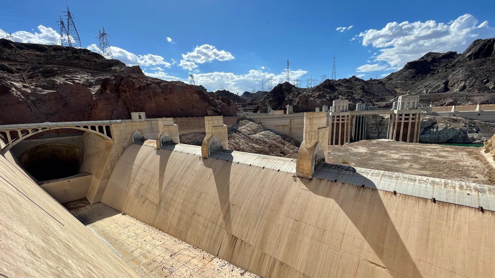
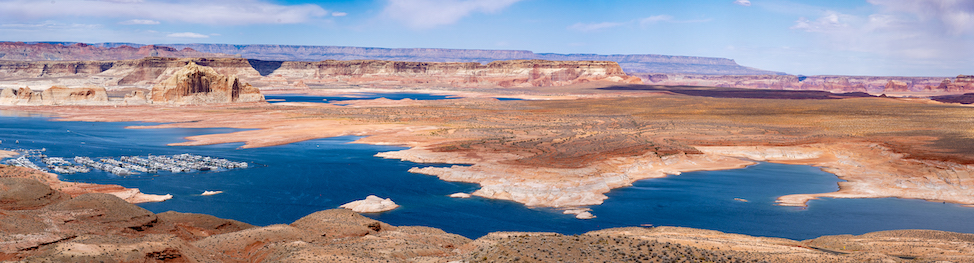
As noted by Tom Yulsman (ImaGeo/Discover), Lake Powell and Lake Mead were both at record lows on August 16, sitting at 26 and 27 percent of capacity, respectively.
“At best, the bureau’s action today will only delay the day of reckoning,” Yulsman wrote.
Interstate Negotiations Locked in a Stalemate
Based on century-old water law (collectively dubbed the Law of the River), each of the two Colorado River Basins is allocated 7.5 million acre-feet of water, with an additional 1.5 million acre-feet allocated to Mexico. Collectively, the lower-basin states consistently use as much of their allocation as allowed per year; the upper-basin states typically use only about 60% of their allocated supply. The reservoir system is designed to store around 60 million acre-feet, or roughly four years of average natural river flow.
Alas, these numbers are based on 20th-century averages that are proving far too generous as populations expand, the climate warms, and reservoir withdrawals routinely exceed recharge.
Bureau of Reclamation Director Camille Touton said in a congressional hearing in June that the seven states of the Colorado River Basin (Arizona, California, Colorado, Nevada, New Mexico, Utah, and Wyoming) will need to somehow come up with cuts of 2 to 4 million acre-feet (or 13-26% of standard allocations) before 2023 in order to stabilize the supply and stave off major reservoir impacts.
“That is a stunning number,” said journalist and Colorado River expert John Fleck (University of New Mexico) in a blog post. As Fleck puts it: “Each Colorado River Basin state has a reasonable argument for why it’s already sacrificed enough. Taken together, though, if each state digs in its heels, there’s not enough water to go around.”
Despite state pledges to cooperate toward meeting the goal set by Touton this summer, negotiations haven’t gotten far.
In a statement on August 16, Tom Buschatzke (director, Arizona Department of Water Resources) and Ted Cooke (general manager, Arizona Project) said: “The Basin States have not yet produced a viable plan nor has the United States proposed a plan that achieves the protection volumes identified by the Commissioner.… It is unacceptable for Arizona to continue to carry a disproportionate burden of reductions for the benefit of others who have not contributed.”
Meanwhile, John Entsminger (general manager, Southern Nevada Water Authority) said in a July 25 letter to the Department of the Interior, as reported by the Las Vegas Review-Journal: “Despite the obvious urgency of the situation, the last sixty-two days produced exactly nothing in terms of meaningful collective action to help forestall the looming crisis… We are at the stage where basin-wide every drop counts, and every single drop we are short of achieving two to four million acre-feet in permanent reductions draws us a step closer to the catastrophic collapse of the system.”
hard to see this moment as anything but a colossal shrug from the colorado river basin’s users in response to the feds.
a culture of defeatism seems to pervade among users and state leaders right now. i’ve heard serious talk of rebuilding on a “post-crash” river.— Luke Runyon (@LukeRunyon) August 15, 2022
Climate Naturally Prone to Megadrought, Say Hello to Human-Produced Climate Change
It’s hard to believe now that the Glen Canyon Dam came perilously close to overtoppingafter the torrential El Niño rains of 1982-83. Wet years and dry years followed during the 1980s and 1990s, but warning lights were already beginning to flash red. A major 1999 EPA report, “A National Assessment of the Impact of Climate Change on Water Resources,” warned (in bold type):
Our results indicate that the western and southwestern regions of the United States are much more vulnerable to climate change than all other regions of the United States largely because those regions depend so heavily upon surface water storage combined with the extreme natural variability in climate in those regions.
Even when there aren’t major shifts in precipitation, a warming climate puts additional stress on arid and semiarid regions by boosting evaporation from soils, rivers, and lakes. Growing populations only add to the water stress.
In the years since 2000, periods of intense drought have combined with a relentless warming across the Southwest.
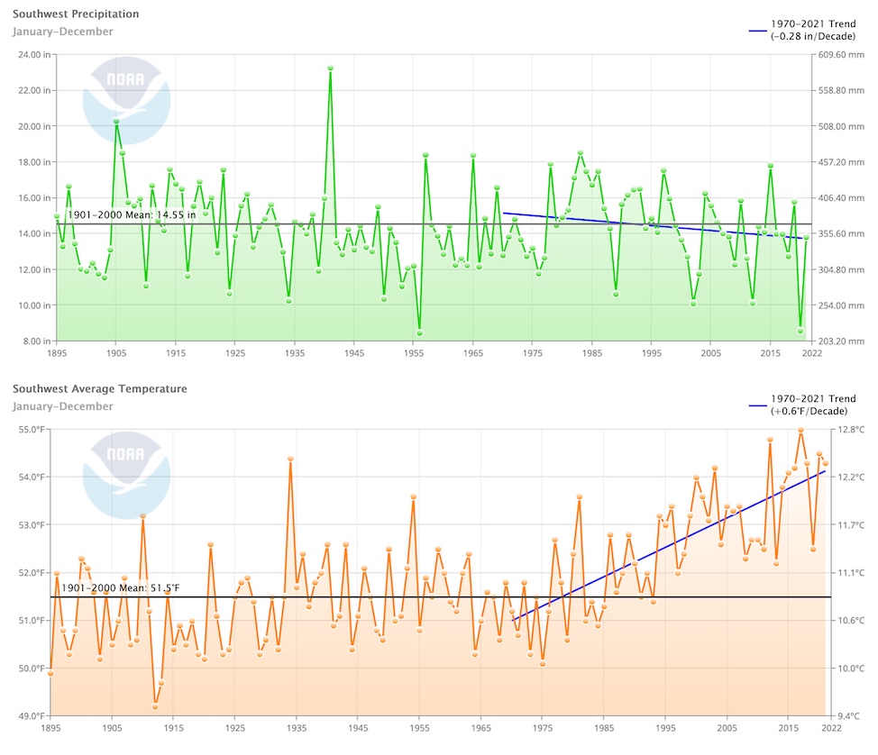
A 2022 study in Nature Climate Change led by Park Williams (University of California, Los Angeles), extending previous work, estimated that the period from 2000 to 2021 marked the driest 22-year stretch over southwestern North America since at least the year 800. Precipitation over this period was 8.3% below the average for 1950-1999 (a period of breakneck population growth), and temperatures were around 1.7 degrees Fahrenheit warmer than that average.
Williams and coauthors predicted that another year of drought was likely in 2022, which would put the length of the current megadrought on par with 1571-1593. Three other megadroughts since 800 lasted even longer, the study found, including a 29-year stretch from 1432 to 1461. And none of those megadroughts occurred in a climate pushed ever warmer by greenhouse gases pumped out on an industrial scale.
The most “restless” summer monsoon season in a decade became deadly as intense lightning and thunderstorms flooded parts of southern Nevada and a leaky ceiling forced table games to stop at one Las Vegas Strip casino. https://t.co/maQj64osaA
— ABC News (@ABC) August 13, 2022
A Stormy Summer or Two Can’t Erase Two Decades of Drought
Much like 2021, the North American Monsoon of 2022 has been quite active at times across the Southwest, leading to the second wettest July day in Death Valley history(with thousand-year estimated rainfall rates) as well as dramatic flash flooding there and in Nogales, Mexico.
More dangerous flooding from Nogales, Sonora yesterday. We’re seeing way too much of this lately. Video courtesy: Francisca Miranda. pic.twitter.com/NuMFG6anzN
— Tucson Weather (@mattbrode) August 14, 2022
The June-July period was the 15th-wettest in 128 years of recordkeeping for Arizona, and June-July 2021 was the second wettest. However, this summer’s rains may not be enough to quench yet another year of regional drought. For the current water year thus far (October 2021-July 2022), the Southwest climate region has received only about 81% of its average precipitation, making it the 24th driest such period on record.
Looking further out, a third consecutive year of La Niña is now well under way, and it is predicted to extend into early 2023. That’s bad news for the Southwest, where La Niña is strongly correlated with drought.
The most recent long-lead climate outlooks from NOAA, issued on July 21, project drier-than-average conditions across the Southwest from autumn 2022 into spring 2023.
Jeff Masters contributed to this post. Website visitors can comment on “Eye on the Storm” posts (see comments policy below). Sign up to receive notices of new postings here.


“the last sixty-two days produced exactly nothing in terms of meaningful collective action to help forestall the looming crisis”. This is the key statement and what you get when you ask states to voluntarily come up with a plan with no real consequences for NOT coming up with a plan. The Tier 2a restrictions were already set to kick in well before the government gave these states a 2-month warning.
The fact that California escapes any cuts is a little mind boggling and a statistical feint. Right now, Lake Mead is at 1,042.48ft (https://mead.uslakes.info/Level/). The government forecasts a level of 1048 by January 1st even though Lake Mead’s level changes from August 17th to January 1st in the previous 2 years were flat. A forecast of 1045.5ft or lower apparently would have kicked in cuts for California.
If DENIAL & catastrophe capitalist feeding frenzies worked (upwardly-redistributing our homes, equity & labor without tangible repercussion from we the peons, until Nov 8) fundamentally, nothing will change, in financializing several million more deaths from exponentially cascading crises? We’d shut down pipelines who’s sole purpose was to sell Marcellus gas 600miles south, to run air-conditioners 24/7 at FAR higher prices due to run-away AGW, from leaky re-re-fracking scores-of-thousands new wells. Or evicting fixed income elder NYC Co-op shareholders to install gas boilers, to move DNC superdelegates’ carbon footprint 140 miles west into Frackistan. Now, “our party’s picking simultaneous wars to save Albright’s fracked LNG/ oil export pyramid?
https://m.youtube.com/watch?v=1VDLRwfYKIU
Driving down the 15 freeway yesterday, it dawned on me how doomed much of Cali is…
They keep building homes and infrastructure nowhere near water, seemingly oblivious to the big dry closing in on them, and all this in one of the last places in a long delivery line of imported water, whose sources are all going tilt.
The thing is, these locales won’t even make for interesting ghost towns, as the infrastructure is so shoddily constructed-there are no structures built to last, everything is somewhat temporal, you too can live a few hours from your work and commit to commute!
Likewise here on the upper stretch of the 15 freeway in Las Vegas. They’re still building new tract homes like it’s the 1960’s and 70’s. Rearranging deck chairs on the Titanic, the Southern Nevada Water District says all “non-functional turf” will be illegal in two years. Why not, “No new water hook-ups”? Oh, that’s because of governmental capture by construction and real estate interests. At least, I would think, Las Vegas will make for an interesting ghost town… on your way to Canada.
On your way to Canada, from where?
Sounds like the mass-homebuilders involved know its all doomed, so they are building fast and flimsy in order to sell and go.
My view of this water-shortage episode is that it provides a preview of how we humans are likely to cope with resource contention.
The western states are hoping for a hail-mary (rain), or failing that, the guy with the biggest stick will prevail. In the short run, some will maintain their lifestyle, most will suffer.
Over in Ukraine, the resource war has gotten so desperate that the NeoCons are now bombing nuke plants. The NeoCon .vs. the World battle is a hegemonic fight over resources.
“What do I have to do to maintain my privileged position in the social order?” is the question on the table. High and low, 1% or 99%, that’s the core question.
A more helpful question might be “how do I help reformulate our economy so that it fixes the planet, and provides a satisfactory living for all of us?”
We are on the Titanic. It’s hit the iceberg, and it’s going to sink. Soon the fights will break out, severely reducing our ability to cope. The people in steerage will perish.
The “Titanic” in this metaphor is our obsolete political economy. What do we produce, how do we produce it, and who gets what.
Several pundits have recently hinted at what’s to come as climate induced collapse starts. They all basically predict lawless chaos. Smithsonian Magazine details what happened to the Pueblo, aka Anasazi people when a 25 year long drought unfolded in the late 1200’s. Not encouraging. Our present drought will likely be worse.
https://www.smithsonianmag.com/history/riddles-of-the-anasazi-85274508/
Lawless. And that’s different from what we have now how?
Chaos I understand, that’s when protesters get too close to the WEF.
Jack Benny
People killing eachother in the streets and in the stores over bottles of water.
Lawless.
Such a stark difference in droughts, it is up close and personal in Europe where the rivers have dwindled to creek status, while those in the southwest live far away from their despair, out of sight out of mind.
Measures demanded of our leaders in the golden state have been on the down low, the only real indication that there is a problem are the large road signs every once in awhile on Cali Highways that are state of the art late 70’s antiques usually utilized for amber alerts, which now say something like “Drought!, Please Use Water Wisely” as their billy club.
I expect a good many in the SoCalist movement to end up in the midwest, pauperazzis
“I expect a good many in the SoCalist movement to end up in the midwest, pauperazzis”
Yes, don’t want them coming here to AZ anymore. Most Arizonans will not be affected for awhile by the drought as the AG industry – 60% of water used in AZ is used by the AG industry – will take the hit first.
It’s basically going to be the population vs Ag vs Semiconductor fabs.
“Free” land in Kansas…
https://marketrealist.com/p/free-land-in-kansas/
It’s telling that with 60 days to come up with a plan, California was unwilling to commit to any cuts beyond the minimal cuts they already agreed to during Stage 2B and 3. It’s also unfortunate that the Feds wouldn’t put their foot down and tell everyone to share a 25% cut for the long term benefit of all who use the river. I suspect in the long term, they will sacrifice Lake Powell to try to keep Lake Mead. And to think in the 1960s the Bureau of Reclamation was seriously planning on a third Dam between Hoover and Glen Canyon.
Interestingly enough, because of the unusual monsoon rains water levels at Lake Mead have actually risen. Over the years droughts come and droughts go. For California it is likely there will soon be a very wet rainy season. That has been the pattern for the past few decades. Everyone during a 3-4 year drought panics. Just when you think doomsday has arrived massive atmospheric rivers hit the west coast. Los Angeles gets 35 inches of rain, the Tahoe Basin gets 150 – 200 inches of snow, the reservoirs overflow with spectacles that draw thousands of spectators. I’ve seen all of this over the past two decades.
I haven’t seen pictures of low water levels that compare with those today of Lake Powell and Lake Mead. The question always for me is, when there is literally no more water will some water have been set aside for drinking water? Or will water tankers arrive on the west coast? What is the plan?
Since 1944, LAX has never gotten 35 inches of rain. The highest was the 1997-1998 “season” when it got 31.28 inches. While I agree that the west is “due” for a massive rainy–or really, snowy–season, LA probably is more likely to get 35 inches about once every 100 years.
http://www.laalmanac.com/weather/we09a.php
Also, if we’re talking Lake Mead and the Colorado, the focus has got to be Colorado, Utah, and Wyoming snows.
The Utah rivers council sent out an email last week explaining that when the Glen Canyon Dam meets Deadpool, it may not be functional to provide tier 2 supports because of how old the infrastructure is.
https://www.deseret.com/utah/2022/8/3/23289790/colorado-river-report-lake-powell-glen-canyon-dam-outdated-drought-water-level-reclamation