Yves here. The Grinch is stalking this Christmas. I’m already hearing of cancelled Christmas plans, although not for weather reasons. A friend in the area was going to drive to the New York metro area, and hired a trucker to drive her car (she’s not willing to fly any more). He pulled up sick with what his MD said was a bacterial lung infection…..based on no testing. He insisted he felt good enough to drive but she was not willing to risk exposure, and even worse, having him get too sick en route to play chauffeur, leaving her to scramble to find a hotel where they could both stay while he recovered.
This post focuses on the considerable weather hazards…but how many are also reworking plans due to sick outs?
BTW this Thursday in Birmingham the low will be 10 degrees and Friday, a high of 22 degrees and a low of 12 degrees.
By Bob Henson. Originally published at Yale Climate Connections
Tens of millions of Americans will find themselves recalibrating – and in some cases canceling – holiday plans over the next week, as an exceptionally intense Arctic front plows across most of the eastern two-thirds of the United States during the run-up to Christmas Day.
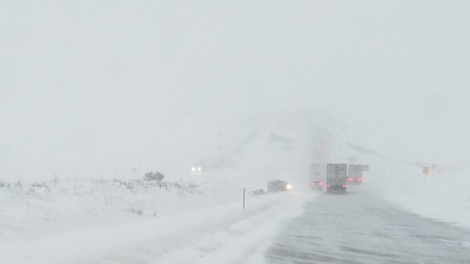
Below-freezing air will push to the Gulf Coast by Christmas weekend, with readings likely to dip below zero Fahrenheit from Oklahoma to Ohio late this week. On top of this, a “bomb” cyclone (one that deepens by at least 24 millibars in 24 hours) will race from the Central Plains to the Great Lakes on Friday and Saturday, December 23-24. Fierce winds and heavy snow are expected to produce widespread blizzard conditions and shut down transportation over portions of the Great Lakes and Midwest on one of the year’s busiest travel weekends.
Heavy rains and high winds will buffet the Mid-Atlantic and Northeast before the front arrives, most likely bringing a burst of cold and a quick shot of snow around Saturday (Christmas Eve).
That is some kinda pressure gradient between the Midwest/Great Lakes blizzard (970s mb) and the arctic High (1050s mb) on Friday. Air travel in the region will be delayed/canceled. And …
MSLP/cold/snow records will be broken. pic.twitter.com/Ic4tkmolIp
— Greg Postel (@GregPostel) December 19, 2022
Driving the hellacious winds will be one of the largest surface pressure contrasts ever recorded across the central United States. Computer models insist that an Arctic high-pressure system will peak with a central pressure between 1055 and 1070 millibars in Montana on Thursday or Friday. This high-pressure system will potentially challenge the all-time record for highest surface pressure in the contiguous U.S. of 1064 millibars, recorded at Miles City, Montana on December 24, 1983, during a historic winter onslaught. (For example, that day was Chicago’s single coldest day on record, with a low of -25 degrees Fahrenheit and a high of -11°F.)
Meanwhile, multiple computer models bring the surface pressure at the center of the winter storm down to the 972-977 millibar range in Michigan on Friday. The all-time lowest surface pressures recorded across Michigan range from about 965 to 972 millibars.
Even where a few inches of snow fall, winds of coming storm will bring blizzard conditions (falling/blowing snow, gusts > 35 mph, visibility 1/4 mile, for 3+ hours). Travel is dangerous or impossible during a blizzard. The 0Z Mon Euro forecast for peak gusts through Sat morning: pic.twitter.com/CvKtSo2Z3g
— Jeff Masters (@DrJeffMasters) December 19, 2022
A Crippling Blizzard Is Increasingly Likely Across the Midwest
The details are not yet crystal clear this far in advance, but it appears that a dangerous and history-making blizzard is in the cards for parts of the Midwest and Great Lakes. The heaviest snow and highest winds are likely to stretch along a band roughly 50 to 100 miles northwest of the surface low as it intensifies near the mid-Mississippi Valley and hurtles toward Michigan.
Depending on the exact track and timing of the low, heavy snow could be accompanied by bone-chilling temperatures and winds gusting to 40-60 mph anywhere from eastern Kansas around Thursday to northwest Michigan around Friday, perhaps including the Chicago area (and the world’s fourth busiest airport, O’Hare).
The intense dynamics of the storm suggest high snowfall rates, mammoth drifting, and exceptionally dangerous conditions for anyone not sheltered safely at home or elsewhere.
Near the Great Lakes, intensified lake-effect snow as well as lakeshore flooding will be serious threats, with total snowfall amounts of one to three feet likely along portions of the Lake Michigan and Lake Superior shoreline.
According to the ECMWF, forecast temperature Wind Chills should be COLD enough to unleash Wind Chill issues for most of the state of Florida. Again the core of the COLD for Florida will be 24-27December. Below is forecast for 26Dec22 from @weathermodels_ pic.twitter.com/IWqHlsRarg
— Jim Cantore (@JimCantore) December 19, 2022
Extreme cold will be a hazard even where snowfall is absent or minimal. Readings could dip below freezing for more than 24 hours as far south as Houston, and below zero Fahrenheit for more than 24 hours from Omaha to Minneapolis. Wind chills will be a particular concern given the unusually dramatic wind potential across much of the Plains and Midwest.
From a forecast discussion issued late Sunday by the National Weather Service office in Chicago: “All indications are that our high temp Christmas Day will be the coldest since the mid 90s and possibly one of the top five coldest on record. Any power outages resulting from the strong winds greatly increase potential danger of the cold spell.”
A frigid Arctic airmass will plunge southward throughout this week, bringing dangerously cold temps & wind chills across the Central & Eastern U.S. As you finish your holiday shopping, take action to protect yourself from the cold. Cold weather safety: https://t.co/cDajZfk6D6 pic.twitter.com/xl8daxPH16
— NWS Weather Prediction Center (@NWSWPC) December 18, 2022
How the Imminent Cold Wave Could Make Its Mark in Weather History
Strength: It doesn’t appear likely the cold wave will set very many, if any, all-time record lows (although this could happen at a few isolated locations if there’s deep snow cover on a clear, calm night near the very center of the cold air mass). It may be tough for some cities to achieve even a daily record low, if only because the timing of this blast will coincide almost perfectly with the many eye-popping records established in the 1983 cold wave.
At most spots, this will be the kind of cold experienced once every few years, even in our human-warmed climate. It may be more dangerous than usual, though, because of the unusually high winds and low wind chills expected.
Duration: One big saving grace of this week’s weather set-up is the progressive nature of the front and associated storm, meaning they appear more likely to hustle through rather than to stall and linger. The coldest conditions should plague any one spot for no more than a couple of days. Long-range forecast models suggest that much or most of the contiguous U.S. should jump back to above-average temperatures during the final few days of 2022.
Timing: Not only is the Arctic blast arriving just before Christmas, but it’ll strike earlier than many of the worst cold outbreaks in U.S. history, before folks are fully acclimated to winter. The vast bulk of below-zero weather across the Plains, Midwest, and Ohio Valley occurs in January and February.
As winters have warmed in recent decades, frigid readings prior to New Year’s have become even less common. For example, in St. Louis, Missouri — where lows could dip below zero Fahrenheit on both Friday and Saturday, December 23 and 24 — there have been 77 winters in 150 years of record-keeping (going back to 1873) with at least one sub-zero reading. Just 15 of those winters had a sub-zero reading prior to Christmas Day. In other words, such pre-Christmas cold struck St. Louis about once a decade on average.
However, the most recent instance was more than 30 years ago: December 21-23, 1989, a stretch that produced the city’s all-time December low of -16°F on December 22.
I’m thinking this map is about to change pic.twitter.com/pSmNUtWjKp
— kaden m (@Weathergeek051) December 19, 2022
Winter Weather and Climate Change
Every weather event now plays out in an atmosphere affected by the addition of greenhouse gases from human activity (mainly the burning of fossil fuels). This doesn’t necessarily mean that every type of weather event will become more extreme or more frequent as a result of human-caused climate change. Like weather itself, the effects of climate change can be variegated, affecting some regions and some types of dangerous weather more than others.
Overall, winters in most parts of the world are getting warmer. That trend is expected to continue in the coming decades. The summary for policymakers of the Sixth Assessment Report of the IPCC, Working Group I, concluded: “It is virtually certain that hot extremes (including heatwaves) have become more frequent and more intense across most land regions since the 1950s, while cold extremes (including cold waves) have become less frequent and less severe.”
As for snowfall, while many winter storms now have access to more water vapor as a result of warming oceans, potentially increasing snowfall in some situations, such enhanced moisture can also push temperatures at any one spot from a snow-making into a rain-making regime. So although it’s well established that rainfall extremes are increasing in our warming climate, changes in snowfall extremes are less straightforward to assess (especially because snow measurement itself is a challenge, and snowfall totals are sensitive to changes in practice).
One intriguing line of research emerged from a series of surprisingly intense winter storms in the U.S. and Europe, as well as a surprising drop in average winter temperatures over Siberia. A scientific debate has now raged for more than a decade on whether the amplified atmospheric warming and increased sea ice loss found over the Arctic might be leading to more-extreme winter weather events in midlatitudes, even if winters as a whole are trending less fearsome over the long term.
As laid out in a series of papers, the core thesis is that the warming Arctic could be making the polar jet stream — and the stratospheric polar vortex it encircles — more unstable and variable. In turn, this could foster vortex displacement events where the polar vortex splits in two, or stretches, thus pushing frigid surface air unusually far south into the midlatitudes. The splitting and stretching could also be influenced by reverberations as the jet stream interacts with enhanced snowfall and high pressure over Siberia during the autumn months.
Scientists across the spectrum of Arctic-midlatitude research have agreed on some points, but there’s still a major split: Simulations from global climate models (including a recent batch specifically tailored to tackle polar-midlatitude relationships) tend to show a weaker correlation between Arctic warming and midlatitude winter weather than what’s actually been found in observational studies. Moreover, the observational links themselves appear to have weakened since the early 2010s, which implies that natural multi-decadal variations could be in the mix as well.
Whether or not the Arctic-midlatitude winter-weather hypothesis stands the test of time, we can’t ignore the threat of winter extremes, as they can persist in a warming climate. By some measures, the cold wave centered in Texas during February 2021 was not the worst one observed there. Yet it triggered a catastrophic failure of the state’s power grid and led to more than 250 deaths in the costliest inflation-adjusted winter storm in modern records.
Jeff Masters contributed to this post.

This explains something that I saw today on a Reddit post. This guy was saying ‘I live in Montana and this Thursday when I go in for work it will be -48 degrees Fahrenheit’–
https://www.reddit.com/r/Damnthatsinteresting/comments/zqe4dd/i_live_in_montana_and_this_thursday_when_i_go_in/
If you are in a cold area at night, perhaps fill up empty soft drink bottles with boiling hot water and have one near your feet and one under your pillow.
When we take our scouts winter camping we recommend this. We also recommend putting the bottle inside a wool sock so as to give it a bit of insulation which extends it ability to radiate heat longer.
Around here they close the main road out by flicking a switch at the police station. The weather really gets nasty at the top of the Niagara escarpment which is the main way out.
To expand on the cold problem – even if you are in a warm house convection against an outside wall will make you feel cold. If you sleep with your head very near an outside wall, you could end up with a headache. Our house is older and is insulated to R12 on the walls – I believe. It is not enough when temperatures dip below -20 C. I place a pillow upright against the headboard, and that does the trick at least as far as close to -40, which is entering record territory around here. Wearing socks to bed also helps a lot.
As far as boiling hot water in soft drink bottles go – just be real careful you don’t end up with a leak or worse. A hot water bottle would undoubtedly be safer.
Speaking of 48 below – anybody remember the Frozen Logger song?
When I lived in a damp stone house in Mallorca, the best foot warmer was hot water in a clay bottle of Bols gin.
Here in San Jose, CA the mornings have been frozzy for the last 6 weeks or so. About 2 months early.
However, for those house hunting, it’s easy to assess (occupied, so warm) house roof insulation quality on frosty mornings. The more frost on the roof, the better the insulation.
There is a snow-country version of that visual assessment rule of thumb. Observe houses in the cold weather after a several-inch-or-more snowfall. The fewer and/or shorter the icicles hanging off the eaves, the better the insulation.
The National Weather Service Hourly Weather Forecast Graph has been important for us. Here’s a guide to set it up:
https://www.weather.gov/wrn/hourly-weather-graph
and here’s a rrandom location in the Ohio Valley:
yes…that and the Surface Analysis Map at NWS are the 2 things i use most often.
here in NW texas hill country, I’m almost ready for this onslaught.
i’ll bring some more firewood in today, and finish wrapping the far flung faucets…and take wednesday off(solstice, time to burn a board with 2022 painted on it,lol)…and thursday morning early, i’ll go shut off the water to everywhere but mom’s house(should do her, too,lol…but her head is like iron), and drain the lines. i deliberately designed the plumbing around here to facilitate this…which saves me time, money and hassle from being a reactionary plumber when it’s still in the 40’s.
as for the hypothesis regarding weakening polar jet meandering and sending arctic air to texas and florida…i’ll hafta hunt for the links, but that can be observed in more or less real time…less differential between pole and equator(since arctic warming faster) means slower circumpolar jet=> that jet/wall of air meanders, sending us bolus of arctic weather.
from friday night through at least sunday night, i’ll be taking the graveyard shift…tending the fires…especially in my little attached greenhouse. the difference between this ice age and those in feb 2022 and especially 2021, is we’ll have sunny days…so the greenhouse will warm up with the sun, and heat the big black barrels of water in there.
give me June, any time.
i loathe winter.
As best I can make out it’s the waves in the circle-of-rope-thing. Push on one segment [“warm jet”], and the whole ensemble gets distorted. The way to see the Tribune’s graphic is to follow this (going to the article doesn’t show it to me). https://duckduckgo.com/?q=chicagotribune+science+behind+cold&t=h_&iar=images&iax=images&ia=images
Robert Scribbler once combined some graphics (or doctored a European illustration) that had the typical warm jet a bit farther west than the one the Tribune illustrated.
https://www.noaa.gov/multimedia/infographic/science-behind-polar-vortex-you-might-want-to-put-on-sweater
Southeastern US, overnight lows in the high teens is gonna be pretty darn cold. Fortunately no precipitation is forecast after Thursday but starting Friday it will stay cold for several days; at or just above freezing temps for the forecast high.
US Midwestern states can have their cold freezes and high winds, I find little about these weather events to enjoy. Bah, humbug.
Currently reading -18 F here in Central Montana. Makes for very disgruntled chickens out in the coop. Poor things haven’t finished molting so they’re a little light on insulation.
Tomorrow supposed to be a high of -21 F before you add the wind chill. It does make the short walk to the mailbox seem like an expedition and even potentially life-threatening.
I am given to understand that New York can get really cold sometimes-
https://www.youtube.com/watch?v=8s9EOeP2vAA (2:07 mins)
Yep, I live in the Mid-Hudson valley and here’s what the local weather gurus are saying “An example of how Friday may play out across the region, by 1pm parts of the valley may approach 60 degrees. By 7pm these same locations will be in the 20’s, by 1AM Saturday in the single digits and teens with wind chills below zero. This is an extreme temperature change, one that will lead to flash freezing of the days runoff, ponding and localized flooding. One that may be coupled with power outages as well.” I fully expect to be without power. I still have a nice woodpile for the woodstove though. Still, the house is big and pipes could freeze and burst if the power is out for an extended period. Fingers crossed
Keep a the faucets open just a bit to let water run through the pipes. Much less chance of freezing pipes.
https://home.howstuffworks.com/home-improvement/plumbing/dripping-faucet-prevent-frozen-pipes.htm
Ski resorts out west last year made snow bank from xmas to new years in the Sierra, there was 10 feet in Tahoe when we skied there the first week of January.
It was one hellova storm, I was riding a chair up with a local who related that it took 13 hours to go from Truckee to Squaw Valley, which is normally 40 minutes with light traffic. He said there were wrecks all over the place, and he got rear ended by a car early in the ordeal and then got rear ended again by the same car hours later.
It was horrible for holiday revenue for the ski resorts as they were closed, it was too stupid with snow to open them.
It did set up the ski resorts quite nicely though for the season, as there was precious little more snow in the winter of our missed content.
Xmas week looks awesome this year with temps in the 40’s on the mountain and mostly sunny.
Water bottles are the bomb, by the way.
Its my secret weapon when winter camping…
We should be relieved that the climate is still capable of producing cold weather in the winter.
Getting ready down here in east central FL. Hard freeze watches going up for the holiday weekend. Family member in western TN told me they are bracing for single digit temps. Glad I am nowhere near an airport nor on a Covid tube aka jet this weekend. Stay warm, safe, and follow common sense.
>”Glad I am nowhere near an airport…”
One poor man at YVR (Vancouver) is close to the airport but unfortunately not close enough.
He contacted our local radio station via cell to say that he and his fellow passengers have been stranded on the tarmac since 8pm (PST) last night. Their plane landed successfully at that time but has been waiting ever since to get to an arrival gate due to heavy snow, poor visibility, and presumably congestion. That’s about twelve hours of sitting (and trying to sleep) on a cramped Christmas flight.
No flights currently departing YVR and people are being told to stay away until further notice.
weather models are having a terrible time forecasting the low and whether or not it digs in over the midwest. forecasters are freaking out like the rest of us over the extreme temps and doing some name calling too. the european model has been the most extreme so far and likely the least accurate.https://twitter.com/The_Weatherman2/status/1605057885876408321/photo/1 on the backside of this it looks above normal temp wise for the lower 48.
on another note https://www.thewirechina.com/2022/12/18/u-s-china-geoengineering/
From the article: “This high-pressure system will potentially challenge the all-time record for highest surface pressure in the contiguous U.S. of 1064 millibars, recorded at Miles City, Montana on December 24, 1983, during a historic winter onslaught. (For example, that day was Chicago’s single coldest day on record, with a low of -25 degrees Fahrenheit and a high of -11°F.)”
I remember that day. I was living in an apartment in Champaign, Illinois. The temperature was -25, with a wind chill reading of -70. Then, in the middle of the day, we smelled smoke in the hallway outside our apartment. The fire department came and discovered that someone in the building had a charcoal fire going right outside the back door of the building. On one of the coldest days on record!
My brother is driving over the mountains today in WA state (I-90) to pick up my nephew who is flying in from Minnesota. 12-18 inches of snow are predicted at the summit of Snoqualmie pass. Bro has a good 4WD rig for snow but it’s going to be dicey and the pass may get closed altogether if there are accidents, which are common in this weather.
In our little town east of the pass, this Wednesday the low is forecast at -8 with a wind chill factor of -22. This is more like what was once normal for this region, but the winters have been getting noticeably warmer compared to 30 years ago. The older I get the more I hate being in the cold – we’re planning to move over to the coast next year where temps are milder so hopefully this will be our last winter here.
Please don’t come to California to get warm. We have earthquakes and drought and forest fires and too much traffic ;)
https://www.wunderground.com/forecast/us/ca/santa-barbara/KCASANTA4113
Merry Christmas to All. . .
Just needed to make a small correction on the caption at the beginning of the article. There is no I87 in Oregon. It was I84 that had a major whiteout in 2017. I remember it well. In Portland we got a foot of snow in 12 hours, pretty much a record.
I hope I don’t lose power
Pro tips: have some food in the refrigerator you can eat without needing a stove to heat and cook. aka pre-hard boiled eggs, cold cuts, some roast meats, lettuce, milk, etc.
And for vegetarians, some pre-made and cooked veg/rice casseroles and side dishes. There are worse things than cold casserole. The refrigerator even without power will very likely keep food cold and safe to eat for several days.
(Ask me how I know. / ha. Several days snowed in over Christmas over 10 years ago.)
So, to be clear, do a bit of cooking now to tide you over any anticipated power outage. / ;)
If the fridge is down because the power is out, and it is below or way below freezing outside, one wonders whether putting containers of water outside and bringing them inside when frozen to put in the fridge will also help keep the fridge cool till the power is back on. Or also those freeze-it chill-packs one sees here and there.
The predicted low keeps changing on my phone, but here in northern Colorado it’s looking like low of -12 on Thursday with a high of 4, and on Friday a low of -13 with a high of 12. There’s a 70% chance of snow tomorrow… but they forecast a 90% chance of snow a week ago and not one flake fell here.
Still have to go out of the house tomorrow and Thursday. When the lows are that low it’s hard to bundle up enough.
Chicago December 23-24-25 1983 records lows for those days will not be broken.
Eh, it’s winter. Those of us in the northern US aren’t surprised. Winter, snow, snow storms, cold weather, dangerously cold weather. Yeah? This is news? We were’n’st born yesterday. But good to have the weather prediction of course to adjust our schedules to the weather forecast. (Which we’ve been doing since, like, for evah.) / oy
notice that wind map is in knots up to 80