Yves here. While the press has made some attempts to identify climate change/environmental feedback loops, they tend to focus on simple ones, like higher temperatures leading to ocean floor and Siberian permafrost methane releases, or polar ice melts leading to heat-reflecting white surfaces being replaced by heat-absorbing dark waters.
This article discusses how severe storms can sluice down burn scars, worsening damage to soil and even creating landslides.
By Amir AghaKouchak. Professor of Civil & Environmental Engineering and Earth System Science, University of California, Irvine. Originally published at openDemocracy
Rivers of muddy water from heavy rainfall raced through city streets as thousands of people evacuated homes downhill from California’s wildfire burn scars amid atmospheric river storms drenching the state in early January 2023.
The evacuations at one point included all of Montecito, home to around 8,000 people – and the site of the state’s deadliest mudslide on record exactly five years earlier.
Wildfire burn scars are particularly risky because wildfires strip away vegetation and make the soil hydrophobic – meaning it is less able to absorb water. A downpour on these vulnerable landscapes can quickly erode the ground, and fast-moving water can carry the debris, rocks and mud with it.
Officials warned of a risk of debris flows near several recently burned areas, including near Santa Barbara and Los Angeles, Monterey and Santa Cruz counties and the Shasta Trinity National Forest.
I study cascading hazards like this, in which consecutive events lead to human disasters. Studies show climate change is raising the risk of multiple compound disasters, including new research showing increasing risks to energy infrastructure.
When Storms Hit Burn Scars
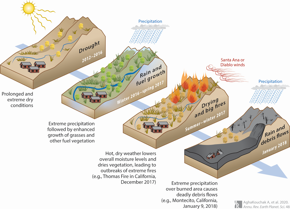
Five years ago, on Jan. 9, 2018, a deadly cascading disaster struck Montecito, a community in the coastal hills near Santa Barbara.
The cascade of events had started many months earlier with a drought, followed by a wet winter that fueled dense growth of vegetation and shrubs. An unusually warm and dry spring and summer followed, and it dried out the vegetation, turning it into fuel ready to burn. That fall, extreme Santa Ana and Diablo winds created the perfect conditions for wildfires.
The Thomas Fire began near Santa Barbara in December 2017 and burned over 280,000 acres. Then, on Jan. 9, 2018, extreme rainfall hit the region – including the burn scar left by the fire. Water raced through the burned landscape above Montecito, eroding the ground and creating the deadliest mudslide-debris flow event in California’s history. More than 400 homes were destroyed in about two hours, and 23 people died.
Video from the 2018 disaster in Montecito shows how quickly a mudslide can overtake a town.
These kinds of cascading events aren’t unique to California. Australia’s Millennium Drought (1997-2009) also ended with devastating floods that inundated urban areas and breached levees. A study linked some of the levee and dike failures to earlier drought conditions, such as cracks forming because of exposure to heat and dryness.
Individually, They Might Not Have Been Disasters
When multiple hazards such as droughts, heat waves, wildfires and extreme rainfall interact, human disasters often result.
The individual hazards might not be very extreme on their own, but combined they can become lethal. These types of events are broadly referred to as compound events. For example, a drought and heat wave might hit at the same time. A cascading event involves compound events in succession, like wildfires followed by downpours and mudslides.
3 significant atmospheric rivers will batter California over the next 10 days, putting a sizeable dent in the ongoing severe drought.
Widespread snow totals of 100+ inches are expected above 8,000 feet in the Sierra, with 6-12″ of rain in NorCal and 3-6″ in SoCal. pic.twitter.com/lBSUTqgkIP
— Colin McCarthy (@US_Stormwatch) December 30, 2022
With compound and cascading events likely to become more common in a warming world, the ability to prepare for and manage multiple hazards will be increasingly essential.
Climate Change Intensifies the Risk
Several research studies have shown that compound events that include both drought and heat waves have become more severe and frequent in recent years. Studies have also shown that droughts and heat waves increase the likelihood of wildfires. And wildfires can also trigger other cascading hazards, turning otherwise unexceptional events into human disasters.
At the same time, extreme rainfall events are expected to intensify in a warming climate. A warmer atmosphere can hold more moisture, leading to wetter storms. This means more burned acres could be exposed to potentially extreme rainfall events in a warmer world.
Cascading hazards are not limited to rain over burned areas. For example, soot and ash deposits on snowpack can increase snowmelt, change the timing of runoff and cause snow-driven flooding.
It’s also important to recognize that human activities and local infrastructure can affect extreme events. Urbanization and deforestation, for example, can intensify flooding and worsen mud or debris flow events and their impacts. That was evident in the videos of muddy water pouring through streets in Santa Barbara County on Jan. 9, 2023.
In a recent study, colleagues and I also looked at the risks to energy infrastructure from cascading disasters involving intense rain over burn areas, focusing on natural gas pipelines and other infrastructure. Our results showed that not only will natural gas infrastructure be increasingly exposed to individual hazards, creating the potential for fires, the chances of cascading hazards are expected to increase substantially in a warming climate.
Managing Multiple Disasters and Climate Change
About a year after the devastating Montecito mudslide in 2018, I visited a location where damage to a natural gas pipeline hit by the mudslide led to a fire that burned multiple homes. Looking upstream, I could see many hills next to one another with similar burned scars, slopes and vegetation cover. Each one can be the ground zero for the next human disaster.
Despite the high risk when extreme rainfall and droughts interact, most research in this area focuses on only rainfall or drought, but not both. Different government agencies oversee flood and drought monitoring, warning and management, even though both are extremes of the same hydrological cycle.
Recent disasters and research show a strong need to integrate management and risk reduction strategies of droughts and flood. Having one agency focus on one hazard can have unintended consequences for another hazard. For example, maximizing reservoir storage when expecting a drought can increase the flood risk.
Emergency response has improved since the 2018 Montecito disaster, but it’s clear that communities and government agencies still aren’t fully prepared for the scale and potential impacts of future events.

I wonder if it would be possible to plant drought resistant, low growth that is fire resistant in the burn scars (succulents?). If that could be done, it would go a long way toward limiting the fires and mudslides. You would need ones with decent root systems that grow fairly quickly.
I was thinking along the same lines. The problem is the fact that the top layer would be still just ash so you would have to plant the roots pretty deep. Long term it would probably best to plant fast-growing trees there to stabilize the area but you would have to be very careful in your choice of what trees to plant. So no eucalyptus trees as they are so dangerous in fires and certainly not those trees susceptible to those beetles that kill trees as then you would be just building up the fire loading of this area.
Aloe vera might be one candidate. It’s relatively fast growing and creates a dense thicket.
Locust trees (Robinia pseudaccacia) has a tremendous root system and allows natural regeneration just from the roots in the soil. Grows quite fast. They were used for sand dune fixation in Romania on tens of thousands of hectares. I have seen stands of 30 m height on sand dunes.
Could they grow without a winter dormancy period each winter in California, the way they evolved to grow with in the East and MidWest?
Groundcover pretty much takes over after a fire here, not allowing any slow growing trees to make purchase, lotsa whitethorn in particular.
Its a bad trade, pine trees for icky low lying plants that are much more flammable in the long run, programmed to burn out essentially.
Succulents do not prevent erosion. The army corps and caltrans used them extensively in coastal and steep areas of California and they have failed miserably. Much of the ‘development’ of housing in the hills of California are poorly conceived and cheaply built, even in wealthy areas such as Montecito. Just like don’t build in a flood plain without expecting to get flooded, don’t build on a hillside of highly unstable soil subject to wildfire, monsoon rain, and earthquakes (always a threat in Cali, just more so now) without expecting failure from time to time.
I agree with you!!! All over California local municipalities allow development on steep hillsides (the views!!) that should remain undeveloped. When the landslides happen (for various reasons and not limited to heavy rains and on burn scar areas) the taxpayers are on the hook for repairs.Socialism is alive and well in California and other states.
PLENTY of native California plants, shrubs, trees are drought-tolerant, fire-resistant and wildlife-supporting.
Buckwheat, Catalina Cherry, Holly-leaf Cherry, Manzanita, Yucca, etc.
The worst thing would be to replant with non-natives.
https://www.cnps.org/flora-magazine/fire-resistant-landscaping-23654
It’ll be interesting to see what becomes of the 100,000+ acres of scorched earth above me, much of it looking like lunar landscapes.
There’s nobody in harms way, for the most part.
And here I thought the burns were largely due to CA mismanaging their forestry department due to the theories of the CA-legislatures and environmental-Nazis against prescribed burns. So along with human encroachment, undergrowth clearing isn’t/wasn’t happening as nature intended (frequent fires that soon burnt out on their own) and instead of fires being allowed to do their thing, human effort to stop wildfires altogether arose as the preferred tactic . . . with predictable results. Thus, it’s human activity, and not just building, which is leading to greater repercussions when lightning and arsonists sparked fires. So along with a dry climate, and Santa Ana winds combining to do their thing as usual, it’s made worse by humans with good intentions but incomplete understanding of cause and effect. Had they let nature do her thing and accepted wildfires as a natural process, then instead of monstrous conflagrations we hadn’t built within these environs and instead of combating it, left fires to burn and clear undergrowth naturally we wouldn’t find ourselves behind the curve. But what do I know? Let’s blame climate change, instead!
You’ll be pleased to know that the feds have got your message, to such an extent that in California’s unprecedentedly huge northern wildfires of a couple years ago, National Forest firefighters let ‘er burn so freely that the homeowners of Ruth Lake have received compensation for enlightened firepersons first starting the fireline (many miles away), then letting it burn through their town without fighting it. State and local firefighters were prevented from interfering, and of course the media is prevented from covering this story, which I’m aware of only from local radio coverage. The backfire that burned Ruth Lake had been set as much as a hundred miles south, before the wind shifted. Federal firefighters are now all in for letting ’em rip. Local firefighters have this thing about saving homes and animals that don’t appear on the federal radar anymore. It’s just hard to make sound decisions from thousands of miles away.
It wasn’t environmental-Nazis who prevented the normal and accustomed Indigenous Burning which the Indigenous Nations did to control fuel buildup to begin with. It was the Manifest DestiNazi European-descended settlers who stopped the Indigenous Burning to begin with. So fuel loads have built up to a point where “controlled burning” will have trouble easing them back down.
If there is going to be “controlled burning”, it should be controlled and prescribed and overseen by the Indigenous persons still alive who retain some knowledge of how, when and why it was done.
Meanwhile, modern man made global warming will dry out more forest and scrub land drier than ever before, for a longer lasting season than ever before, leading to bigger ” restoration of the balance” fires than ever before.
If you live in California, you will be able to see it up close and personal, if you are capable of seeing what you are looking at.
Yves, I really appreciate this. I’m watching the entire state of CA flood and sure, the climate is just fine! /s I’m carefully observing Sacramento where I have extended family. The levees have been an issue since Bob Matsui was on the City Council in the Jurassic Era. When he died in 2005, his wife Doris picked up the cause. I’m not sure the levees are beefed up enough to sustain this onslaught. Note the homes on the Consumnes River are underwater. Someone sent me a flood map and all of the shameless extensive development in the flood zones that were former rice paddies are supposedly “protected by levees”.
https://www.eenews.net/articles/wife-carries-on-husbands-battle-to-guard-capital-city-from-flooding/
From the little I understand, the levees in the Sacramento Delta have received some repairs and maintenance, but like you said, not enough. Besides flooding and sea rise, there are always earthquakes to bust them. Let’s not forget that the flooding could go hundreds of miles east and even, in a OMFG event, get into the Central Valley. I pretty sure that it would be one off event and would slowly go away, just like the Salton Sea, but the sea is still around decades after its accidental creation.
I’m thinking that intensive, planned, multi year (decades?) reforestation and rebuilding of the infrastructure, including serious changes to the building codes perhaps even some rewilding would make all these problems go away. Maybe not all, but most of it for sure.
Despite the volatile environment and they corruption that has always infested California’s government and often its economy since at least the Gold Rush from the state down to the town level, the government successfully built an environment where 39 million people now live. If you need to be impressed, just look at the statewide water system and the remnants of the educational system; however, for over a century the government governed, which means planning, acquiring the resources, and then building for the long term and for the general welfare. The state did its own version of the American System, and like at the national level, it has been burning through a hundred years of creating for short term wealth and political power. Burp.
Blast it. Like with everything else in this state and country, political reform is going to be needed while the whole place is burning, flooding, and falling, not just physically, but socially and economically as well. Can we do the equivalent of replacing the American Wigs, the Pendleton Act (yes, in some ways the Federal/state bureaucracy is that bad, again), the Progressive Movement, and the New Deal all at the same time? All while the environment is falling apart? The country is still wealthy and it has an educated and talented nation, despite the misedumacated clowns running it; it is conceivable, but realistically, is it doable?
Well, since I’m at Ground Zero to the flooding and mudslides, let me just say the commentariat has generally good problem solving instincts. However, finding a non-native plant material that could provide an erosion control, inflammable function on the extensive acreage and steep slopes of SoCal mountains is unlikely: the Chaparral will stay.
The Coastal Range (Monterrey to San Diego) is geologic sedimentary rock that is some of the most naturally crumbly (erosive) rock/soil anywhere in California. And the mountains behind Santa Barbara (Montecito; “little mountain” in Spanish) are quite steep (ridgeline 5000′ and just over a mile from the Pacific Ocean). So keeping soil in place when these intense rains (8″ in 24 hrs.) come, is futile. Gravity wins.
As for the videos, the leading one is actually not a street but the Mission Creek channel that is walled with aesthetically pleasing sandstone. (This is Santa Barbara, kids! Plain concrete is a no-no.) The other videos ARE flooded streets, but that is because the storm drains were not designed for this big rain event. All flood runoff in SB ends up in the ocean and the ocean high-tide restricts outflow 4x a day—it didn’t take long for the incessant intense rainfall to backup the storm drain system.
As i mentioned in yesterdays Comments, the Hwy 101 (freeway) was closed by water/mud from Ventura to SB to Gaviota (roughly 60 miles). Today the freeway is open and Californians are back to speeding.
However, it wasn’t flooding and mud that damaged the SB spirit. These atmospheric rivers have generated 15′ waves that have completely sucked away the broad, sandy beaches that tourists love. The next storm will likely remove beach parking areas and likely seriously damage elements of the SB Harbor. (Dozers are frantically (foolishly?) working to create barriers.)
And we’re partially protected by the Channel Islands. NorCal coast is likely forever transformed.
PS. The sun is peaking through the clouds and warming my cold toes as I type. Tomorrows forecast is more rain.
Thanks for your report and yes you were ground zero for the storm and what a tragedy about the beaches ..
There really isn’t much we can do here to mitigate the situation in Sequoia NP, as planting non natives is a big no no
There is a concept closely adjacent to all this, called “wexleblat disaster”. A natural disaster damages a piece or sector of man-made infrastructure. That damage causes further damage to yet other infrastructure and the people who depend on it, echoing for a while down the halls of cause and effect.
Here is a little article about that.
http://www.wikibin.org/articles/wexelblat-disaster-6.html