You are supporting the habits of the rich in more ways than you know, including their love of water views.
Readers may recall that we wrote about the Biggert-Waters Act, a bill to address rising losses in a Federal flood insurance program that had run on a self-supporting basis until the late 2000s. As New Jersey Spotlight explained:
Congress created the National Flood Insurance Program in the late 1960s after Hurricane Betsy hit New Orleans, causing over a billion dollars in damage. Flood insurance was nearly impossible to secure from the private market, so lawmakers felt the federal government had a duty to step in and provide help to residents along the coast. The program was set up to be self-sustaining, borrowing from the U.S. Treasury only when necessary, and it generally worked for several decades. But beginning in 2005, Hurricanes Katrina, Rita, Wilma and several other storms caused it to blow through its budget and go $24 billion in debt.
The mandated increases under Biggert-Waters started hitting at the same time when FEMA issued new flood maps. This is a periodic process, but the latest version reflected recent experience with more frequent and severe storms. As a result, people whose homes had never been in floodplains (and hence required to buy insurance) were newly included,. Those already in a flood area saw their premiums increase, at a minimum due to Biggert-Waters, plus many were hit by having their home moved into a higher risk category. The result was many faced increases of tens of thousands of dollars in annual premiums. For instance, a Bloomberg headline wailed about seven-fold increases; a NOLA story about St. Tammany Parish listed several cases of more than ten times premium increases.
Biggert-Waters is in the process of being cut down into something that causes homeowners less pain, meaning taxpayers will now as a matter of policy (as opposed to by accident) be subsidizing coastal homes. The Senate passed a bill that would delay rate hikes (those to cover the $24 billion shortfall) by four years. Ooh, but the bill expires in four years! House members want some modifications in the Senate bill, but odds are high that some form of relief or de facto termination of the bill will take place. And some of the rate changes related to the flood map redo are being deferred. CNBC reported that:
Certain homeowners who met previous flooding codes that have since been revised won’t see premium hikes for up to two years—but only because a recent spending bill passed by Congress keeps the agency from using funds to implement the hikes.
But there were some people who managed to insulate themselves from these rate increases: the wealthy who petitioned FEMA for a break. In some cases, these properties had already gotten large insurance payouts in previous storms, and had less well heeled, well connected neighbors who got no rate relief. From NBC (hat tip DB):
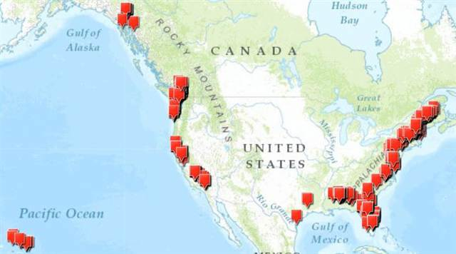
As homeowners around the nation protest skyrocketing premiums for federal flood insurance, the Federal Emergency Management Agency has quietly moved the lines on its flood maps to benefit hundreds of oceanfront condo buildings and million-dollar homes, according to an analysis of federal records by NBC News.
The changes shift the financial burden for the next destructive hurricane, tsunami or tropical storm onto the neighbors of these wealthy beach-dwellers — and ultimately onto all American taxpayers.
In more than 500 instances from the Gulf of Alaska to Bar Harbor, Maine, FEMA has remapped waterfront properties from the highest-risk flood zone, saving the owners as much as 97 percent on the premiums they pay into the financially strained National Flood Insurance Program.
NBC News also found that FEMA has redrawn maps even for properties that have repeatedly filed claims for flood losses from previous storms..
And FEMA has given property owners a break even when the changes are opposed by the town hall official in charge of flood control.
The article goes through some of the 533 cases it found, staring with a section of beach in the coast of Alabama that was flooded during hurricanes in 1995, 1997, 1998, 2004, and 2005:
That’s why flood maps show most of this beach as a “coastal velocity wave zone,” the area with the highest risk of damage from storm surge…From 2011 through 2013, FEMA granted applications remapping 66 out of 72 waterfront condo towers in Gulf Shores to lower-risk flood zones or off the flood maps entirely. Four others have applications pending. Just two applications have been denied. And next door in Orange Beach, the map lines have been redrawn around four high-rise condo buildings.
One condo (a large highrise building) had its premiums reduced by 94%, another by 97%. Neighboring single family homes got no reductions, and some pay premiums several times as large as that of entire condo towers.
The illustrations come from all over the US and include:
A $4 million Hamptons vacation home for an investment manager
A $19 million residence of a former CEO in Naples, Florida
The Mamaroneck Beach & Yacht Club
A tony neighborhood in Hatteras Island
And these gifts don’t stop giving. Emphasis ours:
Giving property owners a method for correcting errors on flood maps is perfectly reasonable, according to national specialists in flood insurance. But considering coastal properties with a history of flooding as low risk has inevitable results, they say:
The owners pay less into the national flood insurance program, where a reduced risk typically means a lower premium. Depending on when the map change is issued, the owners may receive refunds of premiums for the current year and the previous year.
If these properties are damaged in the next hurricane, nor’easter or tsunami, they’re still insured by the national flood program, up to $250,000 in damage to a single-family home, or $250,000 per unit for a condo building, which could add up to $100 million for a high-rise with 400 units…
Being in a less-restrictive flood zone allows owners to use lower construction standards, avoiding breakaway walls and sinking piers and pilings deep into the ground. Such shortcuts encourage overbuilding along the coastline, further increasing the risk to taxpayers.
The condo provision is a doozy, since a flood is presumably only going to damage common areas, any building infrastructure below or at ground, and lower floor units. The insurance per unit provision means the coverage for the units on the higher floors that will not be affected effectively provides a vastly greater effective coverage to these apartment towers than to low rises or single-family homes. Charming.
The next show in this NBC series profiles one of the people who negotiates these super duper discounts for the rich. Stay tuned.


Soon we will realise private insurance doesn’t work as we thought at all and a man with a steel claw runs weather systems from a bunker in an offshore island, collecting the world’s money.
Here’s the dope on how Beyonce got a $425,000 bailout on a home wrecked by Hurricane Ike:
http://m.motherjones.com/blue-marble/2010/04/beyonc%C3%A9s-beach-house-brouhaha
The bigger story that this article illustrates is that, across the board, in every government agency or institution the Game is being rigged for the rich and powerful. Bureaucrats everywhere hop to the Buck $ Beat.
Sorry, don’t have enough outrage left for this one.
Interesting how congress is in one place trying to kill the postal service, and then over here turning flood insurance into a blank check welfare gift
Once again (as if we needed any more evidence), we see that the biggest Welfare Queens are the One Percenters.
Like King Canute!
From Wikipedia:
Henry of Huntingdon, the 12th-century chronicler, tells how Cnut set his throne by the sea shore and commanded the tide to halt and not wet his feet and robes. Yet “continuing to rise as usual [the tide] dashed over his feet and legs without respect to his royal person. Then the king leapt backwards, saying: ‘Let all men know how empty and worthless is the power of kings, for there is none worthy of the name, but He whom heaven, earth, and sea obey by eternal laws.’ He then hung his gold crown on a crucifix, and never wore it again “to the honour of God the almighty King”.[95] This incident is usually misrepresented by popular commentators and politicians as an example of Cnut’s arrogance.[96]
This story may be apocryphal.
I am decidedly not wealthy and have been paying close to $2000 a year for mortgage mandated flood insurance on the home I grew up in, which I bought from my parents (who built it) before they passed away. It has weathered through hurricanes and tornadoes and, although it sits squarely in the flood zone, has never come close to flooding.
I decided to refuse to play the FEMA game. I paid off my mortgage instead. So now I’m cash poor for the year, an anxiety I am more than willing to endure for the opportunity to tell FEMA to take its ever-changing and innaccurate flood mapping and stick it where the moon don’t shine.
Let’s hope the next high water doesn’t get you.
We’re in the floodplain and presently not insured, so I empathize. Unfortunately, the maps are often misleading. The last large flood here stopped about 50 ft. short of the house, which is about 6 inches of water – one heck of a lot, as it happens. The floodway has been improved since then. Unfortunately, especially when the history is fairly short, the “100 year flood” elevation can be pretty arbitrary.
At this moment, the river is out of its banks (but nowhere near threatening the house) and the rain just stopped. That’s good – it’s recharging the aquifer. But the dry weather is a relief, too.
Oh, it gets worse. I worked in county government in the 80s doing land development regulation. While engineering staff worked to comply with FEMA and regional regulations, it was not uncommon for the county commissioners to allow developments that did not comply. The county commissioners were all land developers or their spouses. Although FEMA shook its fists at the county (that is, they sent nasty letters), that county and those developments got FEMA-subsidized flood insurance nonetheless. This was prior to FEMA going bust – and I suspect they are tougher on counties that violate the rules today – but there’s a huge pile of grandfathered non-conforming developments that are being subsidized by current rate- and taxpayers.
And let’s not forget those hurricane ravaged homes that we are paying to rebuild again and again. In my view, if FEMA pays a total loss claim, the house and the land it sits on should become public property.
Sounds like Obamacare… except that the alternative to Obamacare is single payer which would save money whereas if we did broad-based national flood/disaster insurance there would need to be a brand new model to nationalize insurance… not a bad idea if the fools who build in the floodplain have to pay their fair share, or they have an option to pick up and move away.
Great timing! I have recently been doing some (self-imposed, housewife-type) research into the real estate market surrounding The Chesapeake Bay–and the subject is waaaay more fascinating than I thought it would be.This WAPO article focuses on a newer discover than the bolide crater impact, but it sets the newer discovery up with an intro that quickly explains why the geology of the Chesapeake Bay area is so unique.
http://www.washingtonpost.com/national/health-science/seawater-discovered-near-the-chesapeake-bay-is-up-to-150-million-years-old/2013/11/16/096ac7ae-4e10-11e3-be6b-d3d28122e6d4_story.html
(But–really long story short, the Chesapeake Bay impact crater was formed during and after an asteroid hit just off of Cape James, VA, approximately 35 million years ago. It’s now sort of an upside down sombrero-shaped formation, so parts of that region are sinking–in addition to experiencing sea level rise–so it’s a double-whammy for some low-lying areas of VA, MD, as far as flood risk/storm surge is concerned. )
This local news article discusses the flood insurance issue quite broadly, but there’s some awesome information in the article: http://hamptonroads.com/node/679885
But I have some questions that go beyond the scope of the local news article–particularly as pertaining to the (shadow-y-ish) as well as general inventory of foreclosures in that region:
1. Are the TBTF financial entities who claim to now own foreclosed properties in flood-prone areas–maintaining flood policies on them?
2. Will new owners/investors/Rental REIT Trusts be able to get new flood policies?(New policies on some of these (sinking) areas are literally not being written.)
3. Was flood protection taken into consideration when HAMP modifications were being made? (Did the mods create a severing of the flood insurance? Were the mods made with the calculation that due to the severing of old flood insurance policies–new policies may not be obtainable, or might be 4x the cost of prior insurance–thus guaranteeing a mod will fail and revert back into foreclosure?)
4. Large entities, like Ocwen, service, own, auction/sell, bundle into rental REITs these properties–do entities such as Ocwen have a duty to disclose the requirement for/difficulty in and/or high cost of obtaining such insurance to potential buyers/investors,certificate holders?)
5. Do Ocwen’s realtors/brokers/auction houses/affiliates/vendors also have the responsibility of such disclosure?
6. How do GSEs like Fannie, Freddie who offer financing through their programs (Home Steps, Home Path) handle the flood insurance issue with the properties they have in this region?
7. Are these same entities leaving poverty-stricken and flood-prone areas to die of blight (just Zillow Baltimore, MD, or Norfolk, VA?) due to high carrying costs and “burdens” of home ownership? (Hello eminent domain.)
8. Being that we (taxpayers, voters, citizens, neighbors) were not allowed to cramdown via bankruptcy the debt of the unpaid balances on to the TBTFs (which would have left more people in their homes), could we NOW at least be allowed to CRAMDOWN very expensive flood insurance on to the entities who purport to now own these same properties via foreclosure?
(Or do they just get the “upside” of “ownership”–without taking any of the “downside” of “ownership?” They were in such a hot and heavy hurry to quickly foreclose that they didn’t even bother to follow basic real estate transfer/conveyance procedures and laws–only to have these properties sit vacant, crumbling and rotting for two and three years.)
Okay. I will now shut up and hope some of you folks out there can provide some feedback.
But I think this might be a creative way to squeeze a few more of these TBTFs and SIFIs into precarious stress-test situations. :-) bwahahahahaha…..
we do realize that most of the flooding happens not at the beach, but by rivers? in fact there are areas in the mid west that flood almost every year just like clock work. but i do agree that increasing the entitlement that we are paying those who have flood insurance that are in flood prone areas, dont deserve.
and why is it that some of the most pro ‘free market’ activists are now just as opposed to it? maybe cause the fee market would have dropped any possibility of insurance in these areas? driving down the price of the real estate?
Precisely. The 99% get force-fed private health insurance until we literally gag, because free markets.
But the 1% get a nice socialized subsidized flood insurance program, with rights to rebuild, when the private insurers (wisely) refuse to go.
Imagine the right wing howling if a public insurance plan enrollee drinks his way into a taxpayer financed liver transplant, then proceeds to keep drinking when he leaves the hospital.
FEMA’s redos also hit river properties, including people on a creek in Marin Country (we discussed that in a previous post). But I’d assume that more of the really prized properties have ocean views (which the NBC map suggests) and that the FEMA redo was hurricane-related. so the changes hit coastal properties more than inland ones.
“fee market.” Glorious typo, or on purpose?