By Samantha Harrington, who reports for Yale Climate Connections. Originally published at Yale Climate Connections.
Living near the Mississippi River means keeping an eye trained on the water level. That’s something DeAnna Bell in O’Fallon, Illinois, knows all too well. Bell, who was trapped by floodwaters during the record-breaking flood of 1993, has watched again and again as water engulfed her area. In the spring of 2019, record snowmelt and heavy rain conspired to keep her region under threat of flooding well into the fall.
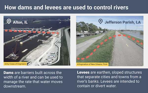
Across the Midwest, river flooding is controlled primarily by dams and levees. But rainstorms in the region are growing more intense as the climate changes, while aging infrastructure is cracking and crumbling. That could require communities along the river banks to try new approaches to flood control – or even to relinquish it.
For Bell and others in the region, frustrations over flood control infrastructure abound.
“People have no clue of how to get things fixed,” she said.
The Risks of Outdated Infrastructure
Many dams and levees across the U.S. are outdated and at risk of failing. According to a 2017 infrastructure report card published by the American Society of Civil engineers, seven out of 10 dams will be older than 50 years by 2025. An estimated 30% of dams were found to have a hazard potential that was either “significant,” meaning there was a risk of damage, or “high” – a risk of loss of life.
Many levees are privately owned, which makes their status more difficult to study. But according to the report card, of the 1,200 levees assessed by the U.S. Army Corp of Engineers, 20% were found to be moderate to high risk.
Investment in updating aging and broken river flood control is limited. In its Infrastructure Report Card, the American Society of Civil Engineers reported that $45 billion is needed to rehabilitate the country’s dams but that only $5.4 billion in funding was available in 2017. Along Midwestern riverways, some infrastructure damaged by flooding in 2019 remains in disrepair.
“High river levels persisted in some areas almost the entire year in 2019, preventing access to even evaluate what damage had been sustained, which is the first step in the repair process,” said John Osterhage, chief of emergency management for the U.S. Army Corps of Engineers’ St. Louis District.
But even if failing river infrastructure is repaired, climate change could soon undo that progress.
River Flood Control Isn’t Always Designed for Climate Change
Designing dams and levees for effective flood control is not an easy task, as precipitation and the consequent river flow can be unpredictable. In the U.S., the average lifetime expectancy of a dam is 50 years. But five decades from now, the climate may be quite different from how it has been, kicking unpredictability up a notch.
Scientists expect that climate change will continue to increase the number and severity of heavy rainstorms in some U.S. regions, but they’re still uncertain about the specific details like how much and how often. Some parts of the U.S., like the Southwest, are expected to have less rain than in the past, while others, such as the Northeast and Midwest, are expected to receive more rain. According to the Fourth National Climate Assessment, the amount of rain falling in the heaviest storms in the Midwest is expected to increase by 40% by 2070-2099 relative to recent decades.
According to Don Duncan, chief of the hydraulics and hydrology branch of the U.S. Army Corps of Engineers’ St. Louis District, for the past several years the Mississippi River has experienced higher stream flows during every season.
“This primes the river to more easily rise to levels not commonly seen in the past, even with normal rainfall,” Duncan said. “Heavy storms will result in even more extreme flooding.”
Baptiste François, a professor of civil and environmental engineering at the University of Massachusetts, Amherst, said that flood-control design often relies on historical records of past flooding. This is the idea of stationarity – that designers can assume that river flows will fall within the same extremes of high and low river levels that have been seen in the past. Yet researchers have actively been discussing the “death” of stationarity as an engineering principle in the era of climate change:
“You have to kind of assume that statistics of your streamflow distribution won’t change in time,” François said. “That’s a big challenge. First, we have some understanding about the climate science that basically tells us that the assumption of stationarity might no longer be true.”
At the moment, flood control design guidelines in the U.S. do not require designers to incorporate climate change into their work. In 2015, the Obama Administration issued an executive order requiring flood risk assessments to be informed by climate science, but the Trump Administration rescinded it in August of 2017.
François said that many engineering companies are reluctant to try new design strategies, which they see as riskier than designing as usual.
“Let’s say if we introduce non-stationarity and we build a levee twice the size of what it should be,” he said. “If the flood distribution doesn’t change, people will blame that because it created a much more expensive project.”
How Might Flood Control be Designed for Climate Change?
Rather than building enormous projects in the face of increased flooding, some places are trying a counterintuitive strategy – relinquishing some control of the river.
In the Netherlands, for example, the government implemented a practice known as “room for the river.” Leaving room for rivers is accomplished by a variety of strategies, such as placing levees farther back from the banks or the river – or not building in the floodplain at all. That enables wetlands to occupy a larger area, which can reduce the impacts of flooding.
“These efforts can be challenging to implement on heavily managed rivers like the Mississippi, because it would require the purchase of large amounts of land from private landowners and large investments in a new levee system,” said Samuel Muñoz, an assistant professor of marine and environmental engineering at Northeastern University.
But some communities along the Mississippi have already tried an approach more along the lines of leaving room for the river. In Iowa, the city of Davenport has long managed flooding without levees or flood walls, the only major city, along the Mississippi to do so. Along the river’s edge, parks and public spaces are designed to handle inundation. A baseball stadium in the park even becomes an island when the river is high.
Such strategies may also save money in the long term. Rural Jersey County, Illinois, for example, suffered a high rate of repeat flood losses in the 1990s. In subsequent years, the county bought out some properties and elevated others. A study by the Army Corps found that conservatively, the county had avoided $2.89 of losses every $1 spent on mitigation, according to Hal Graef, a project manager in the Corps’ St. Louis District.
Leaving room for the river does not always work perfectly, particularly during major floods. Davenport was hit hard by the 2019 spring flooding and many community members wondered if the city should install a flood wall. And buying out and elevating properties would be difficult and expensive in urban areas.
But according to Muñoz, traditional flood control strategies like dams and levees can be more harmful than helpful in some cases. His research found that engineering projects along the lower Mississippi worsened flooding by transforming it from a meandering river to a direct and confined channel. This “artificial channelization” can speed up the rate of water moving downstream during flooding and increase the peak amount of water discharged during a flood.
“If at all possible, make room for the river so that it can periodically flood without devastating your community,” he said. “Investing heavily in aggressive river engineering tends to bring about unintended consequences, and in the long-term may cost more than initially planned.”
“Watch the weather reports, watch the river stages, and be prepared to get out if you have to,” she said. “Know your neighbors if you live in a flood area, and don’t be afraid to ask for help.”


Yes. And here’s another reason to allow flooding – it replenishes topsoil. The major deltas are immensely rich in topsoil – the Skagit delta in Washington has over 30 feet of topsoil, for example. Before the channelization of the river to “control floods” the Skagit delta was a cascading series of beaver-managed seasonal and semi-permanent lakes. The river flooding in the spring and early summer deposited large amounts of mineral soil and increased the depth and quality of the soil every year. This has now been ended – the river has been channelized and all the mineral earth it carries down now deposits in the bay instead of replenishing the delta topsoil. And the beavers are marginal and much reduced.
Now the area is still immensely rich agriculturally as the topsoil is deep and rich – but it is being depleted by intensive farming, mostly of potatoes. SO the natural replenishment of the soil by flooding has been completely stopped by channelization in the name of controlling flooding. Very poor model, unsustainable and stupid.
If we were to re-beaverize and re-floodify the Skagit Delta zone in order to restore fertility-silt deposition, would any kind of agriculture still be possible there to provide some food to certain corners of a desperately overpopulated world?
Maybe! Certainly more seafood would grow out beyond the delta itself once estuary-water mineral re-enrichment were re-restored. But also, perhaps a temperate zone version of Valley of Mexico chinampas might also be do-able. But that would preclude corporate agribusiness operators in favor of personal agriculture craftspeople.
Here is a website about chinampas for people to look at and think about whether it might work in a temperate zone delta.
https://en.wikipedia.org/wiki/Chinampa
And for people who would like to do some image-URL-wormhole searching about chinampas, here is a whole lotta buncha images of chinampas. Some of them link to URLs which wormhole to interesting info-sites.
https://images.search.yahoo.com/search/images;_ylt=A0geK.I3rhRfX4UABB5XNyoA;_ylu=X3oDMTByMjB0aG5zBGNvbG8DYmYxBHBvcwMxBHZ0aWQDBHNlYwNzYw–?p=chinampa+images&fr=sfp
People who think this might be interesting might consider reading it now or at least soon, before the internet goes down, dark and extinct for good. Because once it is gone, it will never ever come back in any form or fashion.
As satisfying as it would be to re-wild the Skagit, it’s not practical- the entire flow above Cascade creek runs through Seattle City Light’s hydro-électrique system at Newhalem. The flows are managed to optimize electricity production and do not coincide with actual seasonal flows. And, the value of the agricultural production is massive. However, much could be done to capture silty water with winter flooding using controlled openings in the levees , if the political will existed.
For me, the looming sea level rise is the most urgent situation requiring engineering solutions. With actual leadership at the federal level , rather than self-dealing corruption and service to monopoly capitalism, it might happen. But Joe flipping Biden ????!!! No way he’s doing anything useful in this regard unless je can get a billion dollar contract for a relative out of it.
” flooding – it replenishes topsoil”
The Egyptians tried to keep Osiris happy to make sure those Nile floods were plentiful every year for just that reason.
Vermont has developed an institutionally integrated an approach to assessing and managing rivers that is geared towards precisely this end: giving rivers room to flood and meander while minimizing flood damage. Limiting/preventing further development in flood hazard areas is one key piece of the program. While impressive progress has been made, there are still myriads of difficulties, and development and infrastructure in floodplains is still vulnerable. A series of disastrous floods over the past 30 years that predates but significantly includes tropical storm Irene has enabled political support for this program, enough so that it is a model example for river management in the US.
Yes, the best flood control is the floodplain!
The Zen Master of river dynamics was Luna Leopold. This link https://www.hup.harvard.edu/catalog.php?isbn=9780674018457 will take you to a brief discussion of his book “A View of the River”.
It is important to recognize that all rivers are not the same. Large watershed, low gradient rivers behave different than small watershed, high gradient “streams” (that become rivers during intense rainfall events).
It’s a little late for giving the flloodplain back to the river; intense dam/levy building has been an American infrastructure staple since the early 1900’s. Encroachment on the floodplain quickly followed. Dams also disrupt the biological ecosystem: anadromous fish diminish; habitat for wild animals (vertabrites and invertabrites, alike) is constrained; natural geomorphic processes recede; plant communities (tree canopy) shrink. The discordant harmony of our ecosystems is now played out of key (tune) and at best on a Pentatonic Scale.
Dam failures and levee failures have opposite outcomes.
A dam failure means that the water held back suddenly surges downstream causing damage for miles downstream. If there is another dam downstream, the sudden increase in river flow can cause failure of that dam as well, which is what happened in Michigan.
A levee failure means that water surges into the area next to the river where the levee breach is and re-occupies the original floodplain. This actually reduces downstream damage because new flood storage is created by the levee breach and the downstream flow decreases a bit.
Lambert, I always appreciate your interest in Mississippi flooding, and follow your occasional links regarding the Old River Control Structure with intense interest. But I especially enjoy it when you flag my hometown, where I still often go to visit family and friends.
This piece from 2018 is awfully rosy — it would be fair to say Davenport has adopted the vision outlined, and the piece makes a great case for that vision. One glaring omission in the article is how this strategy has also been implemented in Davenport’s other flood-prone area, a postwar working-class housing development known as the Garden Addition which has always been hardest-hit by floods. The city has been gradually buying up properties in this area and tearing down houses damaged by floods. But Davenport has only been committed to this vision of “leave room for the river” since 1977, and fulfilling it is a huge, long-term goal with lots of conflicting influences.
A huge percentage of the old downtown has been razed — and not just the riverfront. The reasons for this are complicated, and include: the location of the original town on sandy river bottom surrounded by a flood plain and a quagmire; the timing of Davenport’s development (too early to have realized and compensated for that flaw or for the “historic preservation movement” to have saved it); the de-capitalization of the local and prosperous manufacturing economy and heavy infrastructure (1950-2000); and the effects of the vice trades on real estate development. (Not for nothing did Hearst’s Chicago Daily American call Davenport “The Wickedest City In America” in 1903.) Last, zoning in the automobile age has played a role — nearly every one of these razed buildings was replaced by a parking lot. Check out a satellite view of downtown today for a definition of an urban desert.
Contrary to the strategy of “leave room for the river”, gentrification and development in the flood zone has proceeded. Three blocks of East Second Street were gentrified in the 1990s — and those properties have flooded several times since. A related development project crafted to dispense with the Figge Trust wealth actually doubled down on floodplain development, with a new art gallery and conversion of an old department store into a music performance space. Much of the latter was unusable through most of 2019, and like the public works administrator quoted in this piece, the leadership of the organization had to focus on their building, deferring their actual mission. Several other warehouses on River Drive were converted to lofts years ago, and these are great lofts — except for the flooding. Another issue cropped up in 2019 when the Canadian Northern, whose tracks separate LeClaire Park from downtown, raised their railbed several inches, unannounced.
Even the River Bandit Stadium angle was a bit overplayed; my understanding from locals is that they can deal with minor flooding, but when the river reaches a certain stage, getting to the stadium becomes unsafe/impractical and the games have to be moved. (More generally, minor league ball also faces non-related threats from the pandemic, as well as vulture capitalism.)
Last, there’s a nugget in the infrastructure report which is relevant: the lowest point in downtown Davenport is at River Drive between Iowa and LeClaire Streets — exactly where Lock and Dam 15 adjoins the Iowa bank. This dam was built in the late 1930s, making it now well over 75 years old. Ironically, its construction probably worsened the flooding in that area, because it raised the overall level of the river some 15-20 feet. So this adds another question mark to the long-term plan. Much of that plan could be greatly accelerated were Davenport as heavily capitalized today as it was a century ago.
So, yeah…this concept is well-formed among Davenporters. But implementing it…is not so clean.
Coastal flooding is a side issue here. Along the Mississippi Gulf coast a ‘robust’ gentrification program kicked off after Hurricane Katrina. To that extent, the local landowners, most of whom are direct victims of the Katrina Experience, were “made whole” by then State Governor Barbour right after the disaster, but that was the end of it. Since then, for fifteen years, nothing has been heard about any buy outs of the properties in the flood zones. The building codes were beefed up enough to make building there something only the wealthy can now afford. As one would expect from the ‘Neo-liberal Dispensation,’ the costs of the move from the coastal flood zones are dumped squarely on the shoulders of the middle and working class former denizens of the Coast.
We need to look into the future and develop policies that reduce flooding.Probably the most important this that could be done is to change where we allow development. Simply ban new construction in flood zones.Couple that with moving people out of flood zones by purchasing their property and banning any building on that property. A lot of flooding is the result of thins done by people. We have gotten rid of a lot of mother natures natural flood protection. Land is cleared and developed. Pavement replaces farm fields. This means water runs off very fast instead of being absorbed by the environment. When it rains the water runs offs fast and goes directly into our rivers and streams. It will take leaders with courage to do these things but in the long term we can save lives and decrease damage.
100% agree, floodplain for the win! This post brought to mind two things. One is a successful example of leaving room for flooding from Singapore in their Bishan An Park:
https://www.asla.org/2016awards/169669.html
The second, and concerning thing, is flood control going awry in the lower Mississippi.
https://www.wunderground.com/cat6/If-Old-River-Control-Structure-Fails-Catastrophe-Global-Impact
This is part three of a three part series on the mismanagement of the Mississippi by the ACOE and it’s new path to the gulf which is something is frequently finds. The migration of the Mississippi has been thoroughly documented since the flood control system was built including this excellent essay by the legendary John McPhee;
https://www.newyorker.com/magazine/1987/02/23/atchafalaya
America’s infrastructure bureaucracies have some real reckonings coming, whether it be at the Glen Canyon Dam, anywhere along the Mississippi, or from the sea level rise/hurricanes in the near future. Hopefully reports such as this fall upon powerful and kind ears.
Interesting to see Lock and Dam 26 on here. My stomping ground.
People keep referring to the Mississippi L&D system as flood control. Funny, in 1973 and in 1993, the 100 year flood and it’s bigger sister, the ACOE flatout stated to angry citizens that they were never intended for flood control. That is true, they are intended to keep enough water in the channel for barge traffic, purely a handout to Industrial players.
The only control of flooding possible with a Dam is to move the flooding from downstream to upstream, preferentially.
I have pictures from atop the bluffs at Alton, where you can see the Mississippi merged with the Missouri. Like one giant lake. They are miles apart at normal levels.
That much water is not for mere men to control, I think