Yves here. Yet another example of a planning/zoning problem.
By Greta Jochem, Grist’s news fellow. Originally published at Grist
The rain started to fall in Ellicott City, Maryland on the afternoon of May 27. Nearby tributaries of the Patapsco River were already dangerously swollen from last month’s steady precipitation. The storm intensified, and floodwaters soon tore through Ellicott City’s main street, submerging the first floors of buildings, sweeping away cars, and killing at least one person.
The storm was a so-called “1,000 year flood,” meaning it had a 0.1 percent chance of occurring this year. But this “exceptionally rare” event is deja vu for residents — they’re still picking up the pieces from a similar flood that destroyed the area back in July 2016.
After that big flood, Robin Holliday spent months rebuilding her business, HorseSpirit Arts Gallery. She didn’t expect a flood like that to happen again, but she also didn’t think the proposed watershed management plan was strong enough. Discouraged, she started to think about leaving. The recent flood solidified her decision.
So what’s behind the propensity for floods in Ellicott City? Part of the problem is its vulnerable location: the town lies at the foot of a hill where river branches meet the Patapsco River. And, of course, climate change makes storms wetter and increases the frequency of severe, record-breaking weather. But there’s another thing people are pointing out: concrete.
When hard, impermeable concrete replaces absorbent green spaces, it’s much easier for floodwaters to overwhelm stormwater drainage. “That’s what happened in Ellicott City,” says Marccus Hendricks, an assistant professor at the University of Maryland School of Architecture, Planning, and Preservation.
In Ellicott City, development has flourished.
“Nearly one-third of the Tiber-Hudson sub-watershed that feeds into historic Ellicott City is now covered by roads, rooftops, sidewalks and other hard surfaces that don’t absorb water,” the Baltimore Sun wrote in 2016.
In a press release, the Sierra Club’s Maryland Chapter called for a stop to development in the Tiber-Hudson watershed: “We may not have control over severe weather events (except by fighting climate change), [but] we can take ownership over the role that development played in this disaster.”
At a recent press conference, a local county official said that Howard County, home to Ellicott City, has been taking steps to prepare for more floods.
“We’re focusing on making sure that what has been approved is being done by the code and by law, making sure that stormwater regulations are being abided by,” said Allan Kittleman, the Howard County executive. Since the flood in 2016, he said the county has designed and engineered more stormwater retention facilities, but larger projects will take time.
This is far from the first time that development and asphalt have had a violent run-in with climate change. Last summer, Hurricane Harvey drenched sprawling Houston with trillions of gallons of water and caused $125 billion in damage. The area saw a 25 percent increase in paved surfacesbetween 1996 and 2011, according to Texas A&M professor Samuel Brody. Brody found that every square meter of Houston’s pavement cost about $4,000 more in flood damage.
And, rapidly developing or not, our cities are full of these paved surfaces. In the majority of the country, surfaces like pavement or brick make up just 1 percent of the land. Yet in cities, hardscapes account for upwards of 40 percent of land area.
Environmental change coupled with development will likely make this issue one of major national importance, Brody tells Grist.
“Every week, there’s some urbanized area that floods. We look up and say, ‘Oh that’s never happened before and it’s never going to happen again.’ But if you look at the big picture, it’s happening all the time with increasing severity.”


“If you stop paving, you stop progress. If you stop progress, you destroy America! Is that what you want? To be a tree-huggin commie who hates America?”
So goes the argument. And of course, there are those who argue that these natural disasters are great for the economy. “Look at the increase in spending following the flood! It created hundreds of jobs for people shoveling mud and picking up flotsam!” Bastiat would weep.
It’s an accelerating rush to the wall, but the ride is so good that no one wants to stop, slow down or get off. Mankind is Charley Sheen with ten kilos of coke, a bevy of pornstars and no regard for tomorrow.
I am curious to know if evangelical Christians care about all this? After all, they are expecting the Apocalypse, Earth is nothing to them, and all will be peaches and cream in Paradise.
I know Yves hates this kind of pessimism, but it’s hard to be optimistic when so many Americans call evolution “just a theory” and claim that Global Climate Change is a con created by Al Gore to enrich himself and his “so-called Scientist friends”.
Expat, I think you have something there – the effect of weather disasters on spending. What if we convince Trump that ending our stupid foreign wars would be offset by him acknowledging that climate change is real (firing Pruitt of course), then tell the military industrial complex that the government will take up the slack and give them contracts to harden the country against extreme weather?
Of course, my cynical self is laughing hysterically at the notion of such a prudent shift ever happening.
You’ve just described the 1933 movie “Gabriel Over The White House” with Walter Huston as President.
~~~~~~~~~~~~~
When the film opens, U.S. President Judson C. ‘Judd’ Hammond (Huston) is variously described as “a Hoover-like partisan hack” or “basically a do-nothing crook, based on, to some extent, Warren G. Harding.” Then he causes a near-fatal automobile accident and goes into a coma. Through what Portland State University instructor Dennis Grunes calls “possible divine intervention, (characterized by a breeze blowing through a closed window) Hammond awakens as a decisive man of action.
President Hammond makes “a political U-turn, purging his entire cabinet of “big-business lackeys.” When Congress impeaches him, he responds by declaring martial law, dissolving the legislative branch, assuming the “temporary” power to make laws as he “transforms himself into an all-powerful dictator. He orders the formation of a new “Army of Construction” answerable only to him and nationalizes the manufacture and sale of alcohol.
https://en.wikipedia.org/wiki/Gabriel_Over_the_White_House
I think that I would rather go with “Dave”
https://www.youtube.com/watch?v=PTTe-rxTyh0
Thanks for the Charlie Sheen reference! I will be laughing all day :). Sadly I’ll go back to being dismal tomorrow because it is just as true as it is funny.
Sigh. ExPat, evangelical Christians are not always what you think. A tiny bit of research would have turned up this WikiP article on Evangelical environmentalism and Christian and climate scientist Katherine Hayhoe. Here she explains the difference between religion and science.
The exception proves the rule but does not negate the generalization.
This is also not so much a “planning and zoning problem” as that the baseline data from which the rules were derived have changed.
Our neighbour, Ed, lived in the house next to us when he was little, back in the fifties. He recently moved back into the house after his mother died. His lot was once a swale for drainage, pre-1940’s. The developers put down a drain pipe system and covered it up and built houses over it. For the time, the piping was adequate. Ed says that it almost never flooded through his yard.
Now, the flooding after a big rain event is much more common. I’ve seen it happen in Eds’ yard thrice this year alone. All things being equal, the evidence suggests that localized rain events are becoming heavier. Not more frequent, but heavier when they do occur.
Another example of shovel ready infrastructure projects being ready, but ignored. There are no short term profits to be made from long term projects like this. It’s past time to get the business types out of government.
ambrit, your last three sentences are so important! — Thanks!
It appears that rainfall is getting more intense, but it is also likely that the area leading into the old swale (now a culvert) has been developed, increasing flows into it.
Many of the increasing intensity floods are occurring in rainfalls that are not out of the ordinary. It is very important to differentiate how much of the additional flooding is due to changes in precipitation versus changing the drainage characteristics of the watershed. Much more of the increased flooding is due to the latter vs. the former, so we actually have complete control of it.
Precipitation and flooding are classic statistical distribution problems. On a statistical basis they are relatively rare events (very few days of problem rainfall and flooding in tens of thousands of days). Our accurate databases are only a few decades old and don’t necessarily accurately model the distribution of extreme events. Even inside a given storm, there is a distribution of precipitation inside it, so some of the heaviest precipitation may not even be measured at the gaging station, so it could take a dozen similar storms to come through before the gaging station actually measures the peak precipitation associated with that type of storm – the new Doppler radar systems are getting much better at identifying those variations in precipitation within an individual storm. So some of the precipitation data changes are due to climate change and some are due to ever expanding and improving statistical data sets.
Thank you, Yves.
This post is timely and, due to the bad weather affecting France this month, provoking similar concern and debate. It was the same last autumn.
Yesterday evening’s France 2 news featured this item, https://www.francetvinfo.fr/meteo/inondations/orages-les-villes-face-aux-inondations_2789287.html, about how communities are facing up to flooding. Some solutions were proposed at the end. The report is in French, but one can follow what’s said.
Italy, a mountainous country, has a long history of poor development decisions that exacerbate flooding and landslide events. The most notable being the disaster at Vajont in 1963 (which was an entirely man-made disaster).
https://it.wikipedia.org/wiki/Disastro_del_Vajont
I happened upon an excellent Wiki page of flood events in Italy. The list from 2000-2017 (34) is as long as the one from 1947-1999 (34). 3 times the rate of occurrence. Make of it what you will.
https://it.wikipedia.org/wiki/Lista_di_alluvioni_e_inondazioni_in_Italia
Even if one does not understand Italian, the idea is clear. These things happen again and again as a result of a lack of political will to tackle hydrological remediation and appropriate development in often steep landscapes. Everyone wants that house with a view of the valley.
Cheers!
The same story with bog removal in Ireland. They called it marginal land, because the returns were well … marginal. And so it got drained, and the bog carved up for fuel, and the land used for whatever purpose, inappropriate forestry, agriculture, even development in places. Floods are now common in places that never flooded. And so it goes…
The interesting thing is that, with climate change, the bog is going to reassert itself until people leave there altogether.
I hunt a lot of reclaimed mining sites and quarries. It’s interesting how easily nature retakes those spaces.
For all it’s pride in being a blue state, Maryland is as committed to suburban sprawl as any state can be. It’s letting it’s major city, Baltimore, swirl down the drain. It’s Republican governor, Hogan, is cruising to reelection. Hogan made his fortune building suburban subdivisions and it shows. His solution to Baltimore’s crisis is to turn much of the city into vacant lots. He cancelled a Baltimore subway but is pushing freeway widening in the suburbs and more interchanges. Hogan’s legacy will be more flooding.
Hogan doesn’t get Baltimore. He’sgot the late 20th Century mindset that cities are urban hellholes while nearby Washington DC historic neighborhoods are spiraling out of sight. Baltimore, Charm City, could have a similar renaissance.
There should be no pride in being a blue state. Blue states are the ones with the most corruption. Here where I live in Mass and its a shithole of corruption , our senate presidents and house speakers all wind up in prison. But I look next door at Rhode Island and see it can get a lot worse , they have governors and mayors that leave office in shackles.
I don’t think the average American has a real clue about political corruption and backdoor deals. A reporter friend in New York tells me the state is quite corrupt. Meanwhile, there doesn’t seem to be much howling about Scott Pruitt’s dozen scandals–particularly since he’d doing the bidding of the oligarchs–or that Trump is filling the swamp with more alligators.
The primary retirement plan for NYS legislative leaders seems to be all-expense paid housing in a NYS jail. It is good to see that after all of their lawyers are done with appeals etc., the corrupt leaders get found guilty a second time. The governors also seem to leave in the middle of scandal as well.
Hell, Teddy Roosevelt said that NY state politics was far worse than federal politics.
Harpers had a great article back in 2010 about NY state politics, it’s fantastic: https://harpers.org/archive/2010/05/the-albany-handshake/ (behind a paywall, but I think that was the article where I saw the TR quote)
Well, from the photo, it appears that natural processes can deal with the excess of concrete and impermeable surfaces quite well. Mother Nature does have a plan and it’s always best to align with it.
It isn’t so much that given cities or states are unprepared for floods-although it’s certainly part of the equation, but we’re talking so much rain that there isn’t much you can do.
There was a rainstorm a few months ago in Hawaii that dropped 48 inches worth in less than 24 hours, how do you combat that?
Or the rainstorm in Japan a few years ago that let loose with 20+ inches in 24 hours?
Pavement is not necessarily the problem:
Someone I know lives three blocks from a creek fed from mountains looming 4,000 ft to the east. Her house is just outside the 100-year flood zone, which ends a block closer to the creek and a foot or two lower in elevation.
This theoretical fact means nothing if a monsoon storm parks itself over the mountain and just keeps on raining. Thousand-year floods follow a fat-tailed statistical distribution, not the well-behaved Guassian normal bell curve which we would all prefer. Weather is inherently wild.
US 43 runs parallel to the Big Thompson River. Which makes for very interesting flood warning signs. No words on them, just an image of a stick figure climbing a steep cliff.
i remember that, and reading about it the next day in a special edition of the late rocky mountain news.
Calgary, Alberta and other towns and cities along the Bow and other rivers had major flash flooding due to major storms in the Rocky Mountains. https://en.wikipedia.org/wiki/2013_Alberta_floods
http://www.cbc.ca/news/canada/calgary/city-flood-dam-bow-1.4655745
Many of these cities and towns have significant areas constructed on the floodplains of these rivers. The floodplains have numerous cobbles and boulders in the soils indicating they were built from large high-velocity floods able to move particles that size long distances, similar to the cobbles found away from the mountains in LA.
These are generally arid areas that have no risk of flooding in normal years and decades. However, when the right meteorological conditions set up in a rare event, the intense rainfall amounts take over. Climate change may make these more frequent and bigger because there is more water in the atmosphere, but its not like they never happened before. The occurrence will still be statistically rare, just a bit more frequent and bigger. However, if it only happens once every 50-100 years, it can cause a huge amount of damage as a lot of expensive fixed infrastructure gets developed assuming something like this will never happen. These are the lessons of Hurricane Andrew and Tropical Storm Harvey as well.
Ok folks. I live in Western Maryland, am a Sierra Club member, and I’m the former Director of Conservation for NJ Audubon Society, from the NJ famous for flooding in the Passaic River valley, and most infamously in Wayne, NJ. NJ had lost almost half its wetlands before it passed the nation’s toughest freshwater wetlands protection act in the late 1980’s. The Army Corps of Engineers and the USGS had some great charts linking the degree of wetland loss and impervious surface cover in a given watershed to flooding potential. My point in saying this is that in the Ellicott City situation is that there we are all coming very late to the game, in a situation, a physical setting where even the Wikipedia write-up of the city and its history tells us this in the section on flooding:
“The town is prone to flooding from the Patapsco River and its tributary the Tiber River. These floods have had a major impact on the history of the town, often destroying important businesses and killing many. Ellicott City has had major devastating floods in 1817, 1837, 1868,[58] 1901, 1917, 1923, 1938, 1942, 1952, 1956, 1972 (Hurricane Agnes), 1975 (Hurricane Eloise), 1989, 2011, 2016, and 2018. The 1868 flood washed away 14 houses, killing 39 to 43 (accounts vary) in and around Ellicott City. It wiped out the Granite Manufacturing Cotton Mill, Charles A. Gambrill’s Patapsco Mill, John Lee Carroll’s mill buildings, and dozens of homes.[58] One mill was rebuilt by Charles Gambrill, which remained in operation until a fire in 1916.[10]:36”
In another section, not mentioned here, the early industrial structures were wiped out – a grain mill I believe, were wiped out in the mid-18th century.
So the much later intensification of impervious surface cover only made an already untenable geographic-hydrologic situation worse.
There is no inexpensive solution, because retrofitting is very difficult to do. The protocols of modern stormwater magagement for building sites call for pervious pavement of all types, keeping stormwater onsite and letting infiltrate back deep into the soil. So the ugly “detention basin” era has been out for some time in favor of rain gardens and wetland impoundments – good for wildlife enhancement as well.
But we live in an age in Maryland where Governor Larry Hogan was elected in a surprise victory in 2014 on an anti-regulatory platform, and the state’s very powerful building and real estate interests rallied small business types and Libertarians to denounce the state’s stormwater tax aimed at keeping pollution out of the Chesapeake Bay. Taxing the rain! was the rallying cry.
And I just witnessed these powerful business forces block even mild reforms in Maryland’s, faux regulatory Forest Conservation Act, which is not regulatory at all. Relevant for reducing future flooding, water pollution and pulling carbon dioxide out of the atmosphere, for fighting global warming – and for future employment for a CCC/WPA ecological restoration effort? You bet. These powerful real estate and building interests would have none of that, complaining that Maryland already has a thicket of regulations – true enough compared to the awful environmental faking that Virginia and Pennsylvania and West Virginia play pretend with – but very effective rhetorically to threaten any potentially tougher reform efforts in Maryland.
I’ve joke – in part – that the best thing would be for Ellicott City residents to come West to Cumberland and Frostburg in Mountain Maryland and help fill in all the vacant storefronts and abandoned houses in our area. Not likely: if we can’t get a CCC today – one of the most popular of the New Deal programs, we’re not likely to get one of its modernized “relocation” “resettlement” programs, which were not popular, despite the human and ecological “good intentions.”
So that’s where we are, from the eyes a Maryland resident in the middle of the arguments.
FWIW, there are also permeable type paving systems that can be used in many places where currently it is asphalt or concrete or some other non porous material that prevents water seepage over large areas. But as usual, towns and cities are slow to change their ever more complex and burdensome codes that are written up in the first place mainly by vested commercial building industries.
https://www.vbgov.com/government/offices/eso/Documents/permeable-fact-sheet.pdf
Stormwater detention and infiltration can be done underground as well. You don’t have to use up space with ponds etc. You can build pavements right on top of detention and infiltration. It costs some money, but can be done with parking lot retrofits etc. and can dramatically reduce runoff from impervious sites. It is an option that developers can use to meet the stringent stormwater requirements in more regulated areas. Astonishingly, the areas with those regulations tend to not have serious problems with flooding except in low-lying areas in natural floodplains.
http://www.conteches.com/products/stormwater-management/detention-and-infiltration?gclid=CjwKCAjwr-PYBRB8EiwALtjbz-lUclt-DreInOWcLnTUku2SWtiF58VTw_o4CgbG-j166PvWKHypthoC6swQAvD_BwE
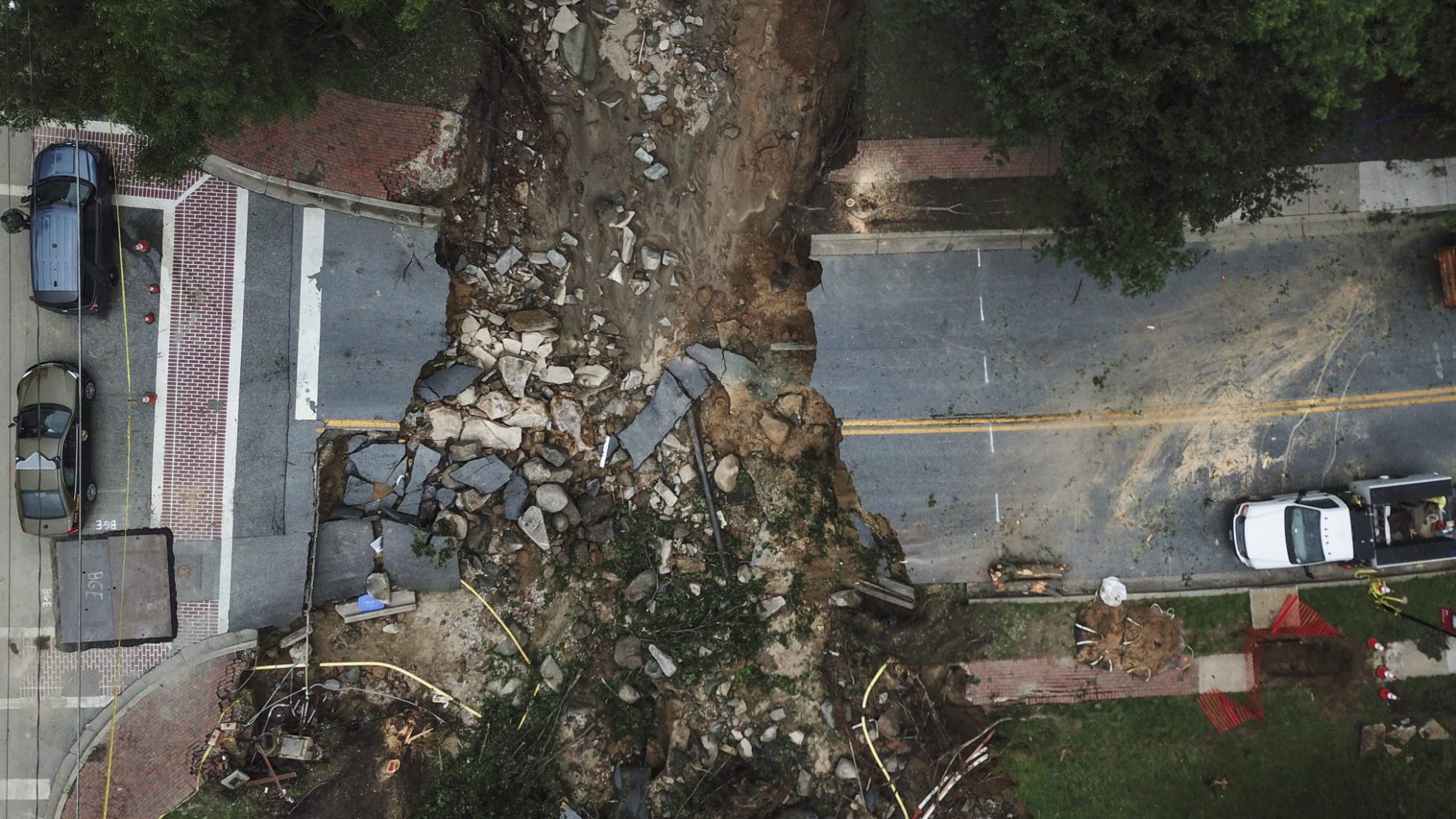
NB the photo is just upstream from where the water washed away the old courthouse from the 1830s. The creek goes into a culvert to go underneath of a parking lot and with the culvert backing up the water had to go somewhere.
On the one hand all that pavement definitely makes flooding worse. But >6″ of rain in a short period of time as a LOT of rain, much more than can be absorbed by plants and soil. That water is going to go somewhere and that somewhere is downhill. A friend of mine said “I like to visit Ellicott City….but I always check the weather first.
Asphalt and other hard surfaces do three things:
1. Increases total runoff;
2. Increases the speed at which runoff concentrates;
3. Reduces infiltration into groundwater.
The nirvana of deregulation means that our cities are a “tragedy of the commons” for stormwater and flood management. It isn’t in the interest of any developer to put in a whole bunch of detention, retention, and infiltration facilities if nobody else is.
We had a warm April storm that was all rain from 13k on down, and up in the Mineral King part of Sequoia NP, flooding took out about 1/4 of a mile of what used to be asphalt road as if it never even existed.
Generally, it never rains up that high, but that was then and this is now.
One way or another, our dependence on fossil fuels is undoing us. Too many cars, too many trucks, too many roads and streets, too many parking lots, when we should be walking or riding bikes, living where we work, and, when goods or people need to move long distances, moving them by train or ship. Mowed grass, as in lawns, highway verges, and golf courses(!!) doesn’t absorb rainwater well, either, and often requires vast amounts of water to stay ‘pretty’. Rain barrels, urban farming, agricultural diversification instead of monocropping. We need to focus on economic and, concomitantly, population stability/thriving rather than ‘groaf’.
Too Many Humans, as the Rice Farmer is wont to say. Until that little item is dealt with…
well, we don’t have to lose a few billion in population to deal with the worst consequences of agw, we have to get off fossil fuels.
And increase the amount of plant growth.
And increase the amount of bio-carbon re-capture and re-injection into the soil for re-storage in the soil.
I’d like to point out something about the image of the undermined street. It shows that Ellicott City did have money to spend on its road system. (100 to 1, it was ‘grant money’ ultimately traceable back to some federal agency, whose distant source reduced the local incentive to handle it with careful stewardship – but that’s another subject.) At this intersection, however, the city did not spend the money on engineering a more effectively performing infrastructure, which might have included a permeable paving material. Instead, it spent the money on surface aesthetics. It bought fancy sidewalks and crosswalks made of brick laid in patterns. Instead of real safety, the city bought eyewash – a form of ‘commodity aesthetics’ deemed helpful to churning the local real estate, and keeping its prices moving ever upward. We see in this image how the American ‘growth imperative’ _ looks_. (Hat tip to Brooklin Bridge, whose comment is very apposite.)
I grew up and have spent most of my 62 years in Ellicott City or the adjacent town of Catonsville. Growing up we never knew of Tiber Run, to us it was Turd Run. Most of the news reports leave out the fact that the city was built directly over top of the natural stream bed. I’m not aware of that much development upstream. The watershed just isn’t that big and at least on one side the slopes are so steep building wouldn’t be feasible.
Actually the pavement issue can also happen naturally. In the Texas Hill country a lot of places have bare rock exposed so no soil to absorb water. Thus the hill country is called the flash flood capital of the US. (Bare rock (limestone) and pavement are similar in runoff characteristics). This is why the big floods in Wimberly happened a couple of years ago. There is a lot of very thin to no soil region in the drainage basic of the Blanco river, so when 10-to inches of rain fell over the headwaters of the river the 40 foot wall of water happened. Articles also talk about removal of vegatation, but similar floods have happened in undeveloped areas of the hill country such as the one caused by 40 inches of rain over several days.
John McPhee wrote a classic New Yorker story in 1988 on Los Angeles’s attempts to deal with similar challenges. https://www.newyorker.com/magazine/1988/09/26/los-angeles-against-the-mountains-i
John McPhee is a favorite around here: https://www.nakedcapitalism.com/2017/09/links-91917.html#comment-2862727
My favorite is the Basin & Range series: RHAPSODIST OF DEEP TIME.
rd,
McPhee’s “Los Angeles Against the Mountains” is also one of three parts of his book “Control of Nature.” The other two are “Atchafalaya”, on the Corps of Engineers’ work to prevent the Mississippi from re-occupying the Atchafalaya channel, which would isolate cities and many billions of dollars of investments in petrochemical infrastructure from the river; and “Cooling the Lava” which describes Iceland’s attempt–they succeeded–to prevent the country’s major fishing port from being closed off by lava curing an eruption.
The book is worth attention. Truth to tell, anything by John McPhee is.
I’m pleased to announce the launch of bitumencoin, whose value varies based upon need of new asphalt.
This is not a 1000 year flood, any more than brain damage around a lead smelter is random heavy metal poisoning.
This is human created, and can be humanly fixed.
In the short term using porous paving materials might help, though that costs money, so on the developments above Ellicott City pull off the paving on the roads and make them gravel.
Yes.
This is why Los Angeles developers scuttled the Olmsted-Bartholomew LA County Open Space Plan (1930) that provided wide swaths of open space for the local mountain runoff to make its way to the sea (Pacific Ocean). That open space is today all covered with developer homes and roads (concrete & asphalt). The runoff is now confined to a 51 mile long concrete channel known as the LA River. However, the 100 yr. “design storm” capability will be readily breached with a modern climate change storm event.
It should be made clear to the public that some storm events, no matter the land use (housing or agriculture) will cause widespread flooding (and damage). For the technically inclined I would suggest the text “Flood Control Controversy” by Luna Leopold. Or “A View of the River”, ibid, for a broader discussion of the impacts of rivers and runoff.
The above comment was a response to “rd”.
The Sacramento area is an area that historically had massive floods and can have a Houston Harvey-type of event. http://www.sacbee.com/news/state/california/water-and-drought/article170234577.html
There was a massive flood in 1861 (more than 100 years ago, so presumably doesn’t count now): http://www.safca.org/history.html
The thing about California is, we have had massive floods in the past, but the Indian eyewitnesses largely left no tales of what went down, so it’s a blank slate from a human perspective, but the flooding itself left lots of clues, for instance there was a flood in 1825 that created the Balboa Peninsula in Newport Beach, and also changed the course of the Santa Anna River. Must’ve been something else!
Imagine the same thing happening today?
The area directly north of downtown Sacramento (AKA “North Natomas”) is 20′ underwater floodplain surrounded by weak levees. It’s so unsuited for development that a federal grant to increase regional sewer capacity specified that if the capacity served such an unsuitable area as North Natomas, there would be a $6M penalty. The land speculators didn’t bat an eye. They went all the way to then-vice-president G.H.W. Bush and got the $6M payable in installments, and, not incidentally, got a $43 million grant to improve the levees to pre-Katrina standards. That’s a pretty good deal right there: pay $6 in installments and get $43. Where do I sign?!
But wait! There’s more!
The speculators bought the land for about $2K an acre, and sold it to builders for roughly 100 times more than they paid for it (or for the strike price of their options). So that’s a 10,000% gross profit.
Of course if they 1031 exchange out of the transaction that lets them “earn” such an egregious profit, they do not even pay income tax on the profit(!)… Again: Where do I sign?!
In Germany, the developers have to sell the outlying land to the local government at the ag land price, then repurchase it at the development land price. The “unearned increment”–that 10,000% profit–accrues to the public’s benefit.
NC readers know Germany is not without problems, but it still has single-payer health care, free college tuition even for foreigners, and the City of Berlin’s arts budget exceeds the National Endowment for the Arts for the U.S. of A.
I haven’t mentioned a couple of stadium deals that continue to make North Natomas a part of looting Sacramento’s economy, but be assured with such outrageous profits the speculators can afford to purchase a sports franchise to drum up a constituency clamoring for an upzone. After all, both Dwight Eisenhower and George W. Bush were cheerleaders too…(and David Cay Johnston reports that 75% of W’s net worth comes from a stadium deal in Arlington TX).
Land speculation remains big business (actually “big racket”) in California, and the fact that the residents of North Natomas now have to come up with the money to raise those levees to post-Katrina standards so they don’t experience those 1,000 year floods deters the speculation not at all. They’re proposing to expand the development area of North Natomas now.
From the picture it looks like Mother Nature has shown them exactly where she wants the water to flow so they should just deepen that trough to accomodate it. Problem solved.
Yeah but I need to get to the trendy downtown area without being inconvenienced in the least.
Optimal water flow and on-site retention for ecological foodscaping/agriculture are among the first issues that are tackled in Permaculture design.
These provide a toolkit of analysis and design solutions from the micro (a back yard) to regional geobiomes (farms, ranches and managed forests covering hundreds of thousands of acres). These sensible Permaculture ag design ideas not only make handling droughts easier, it can also be used to accommodate for extreme rainfall events.
This shows up in near contour keyline plowing, when appropriate, swales, all to encourage a slow, slightly off-contour, balanced movement of water everywhere on the property, and down into the ground for cleaning and storage of water. Water can be routed away from waterlogged valleys out to the dryer, poor growing, ridges and prominences. Water which wants to flow directly downhill can be routed with simple earthworks to making the longest zig-zag journey possible, with switchbacks at each end with water holding depressions or outright bulge ponds.
These approaches rapidly, in a few years (decades scale) convert impermeable clay and subsoil, into permeable black better growing loamy top-soil, while also allowing the much more productive property to sequester massive amounts of CO2 in the soil as humus. This far and away compensates for the over-estimated impact of cows belching methane. As good water management improves growth on the land it also protects riperian, river, areas. We have seen what had been 2 season creeks for many decades return back to four season creeks when enough farmers and landowner adopt Permaculture approaches.
Out here in the West, power struggles and water wars have shaped a great deal of law. And bad law can trump good sense. Also, the old history of land speculators and property boosters, is alive and well outside the metropolis, and an old boys get rich network (as opposed to the knowledgeable old hands) is doing land grabs to make concrete covered sub-divisions, that are illegal in the Urban Boundary rules, and now millions of acres have questionable deeds and debatable private property provenance.
Specifically, here in Jackson County in Southern Oregon, we have met resistance to environmentally advantageous farming and sabotage of farmers by upper management of the county Planning Department. Evidence suggests regulatory capture. Perhaps, kick-backs by the developers to the upper levels of this corrupt county government are to blame. Perhaps it is cognitive capture and a plan to grow more city and concrete. This comes at a cost of prime agricultural land to support a growing population locally. Perhaps it is more for the desire for ostentatious McMansions on a country estate on every hill and strip malls in every valley.
The Planning Department most recently used crass fearmongering around cannabis in power plays to justify throwing out the Urban Boundary concept and violate a very environmentally sensible Comprehensive Plan for Jackson County. In the process, sabotaging long stable land-use law in order to grab the legal power at the state level to slash agriculture acreage.
In summary, a lot of established, if complex, methods exist to help the planet avoid a climate crisis and better manage, clean and recycle water while growing diverse polyculture farms. There is a rural parallel to the political-economic deluge of bad choices from the Davros set.
There have been a lot of mentions of the use of permeable paving–let me take this chance to emphasize that along with making paving more permeable, we can also simply reduce the amount of paving required by getting rid of things like mandatory minimum parking requirements. Parking minimums have no empirical basis, and mandate inefficiency–not to mention they needlessly exacerbate runoff!
Parking lots at the mall are sized for the busiest shopping day of the year. Temporary lots and on-street parking are typically discounted by the terms of tenant leases. Most of the time, though, the parking lots are 2/3 vacant.
Sprawl not only builds malls, it sabotages access for pedestrians, making transit impossible. The promise of self-driving cars, Uber, Lyft, Via, etc. is that even sprawl will have viable transit because technology makes it possible. Calling this an “iffy” proposition strains the limits of the adjective “iffy.”
In better news, the State of California is starting to recognize the problem. Their extremely indirect solutions: “Complete Streets” (streets that accommodate pedestrian access, not just autos), and an emphasis on reducing vehicle miles traveled rather than optimizing “Level of Service” (i.e. street capacity for traffic) in street design. These are fairly large deals, and perhaps, with the recent push to reduce homelessness and increase affordable housing, they will make some progress in the right direction.
Fingers crossed…