Yves here. Bringing you the very best in disaster porn! I don’t mean to sound cheery, but it isn’t pleasant knowing that citizens at large are interested in natural disasters, whether out of awe of nature, knowing people personally who might be at risk, trying to get a sense of how extensive and severe the damage and human costs were, or prurient interest. But I am not even sure that the word disaster will remain appropriate. More extreme weather means more extreme outcomes, like the tail-end-of-Ida flooding. Will we need new nomenclature as this sort of thing becomes normal, or at least not rare?
By Bob Henson and Jeff Masters. Originally published at Yale Climate Connections
Some of the worst urban flash flooding in U.S. history struck the New York City area on Wednesday night, as the remnants of once-category 4 Hurricane Ida teamed up with a frontal zone, upper-level energy, and an influx of tropical moisture to dump historic rains across the Northeast. Countless homes and businesses were flooded, some severely, and the nation’s largest city was brought to a virtual standstill, with scenes that seemed drawn from an apocalyptic future.
As of midday Thursday, at least 18 storm-related fatalities had been reported across the mid-Atlantic and Northeast, following at least five deaths in Louisiana and Alabama. Wednesday’s deaths and injuries and the day’s immense damage will seal Ida’s place in the pantheon of catastrophic U.S. hurricanes, including Camille of 1969 and Ivan of 2004, that made disastrous Gulf Coast landfalls followed by massive flooding or tornado outbreaks east of the Appalachians.
Millions Thrown into a Sudden Nightmare of Flooding
Ex-Ida saved its parting shot for one of the most densely populated corridors along the U.S. East Coast. By late Wednesday night, the largest series of flash flood emergencies ever issued by the National Weather Service had played out from south central Pennsylvania to southern New England.
Knickerbocker Avenue in Brooklyn
New York City #Ida
pic.twitter.com/zAQ8kIIDi4— David Begnaud (@DavidBegnaud) September 2, 2021
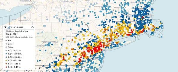
At the peak of the deluge, rainfall rates were astonishingly high. Radar estimates show widespread peak rates of 3-4 inches per hour from eastern Pennsylvania to southwest Connecticut. A New York State Mesonet site in Staten Island recorded 1.6 inches of rain in just 15 minutes, the second highest 15-minute total on record for any NYS Mesonet station. The New York State Mesonet, established in 2014, is a network of more than 100 weather stations across the state.
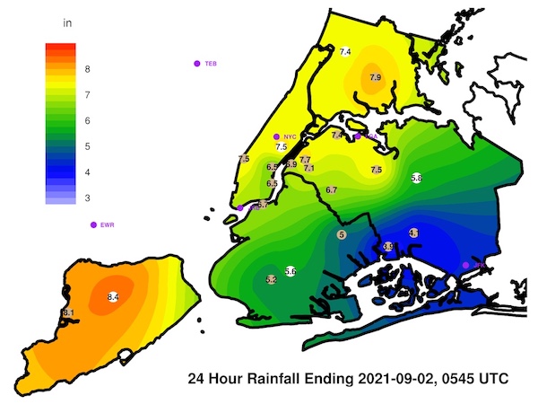
Wednesday’s rainfall total of 8.41 inches at Newark, New Jersey, was the highest for any calendar day in Newark records dating all the way back to 1843, according to weather historian Christopher Burt. It also ranks as the highest calendar-day total for any of the major NYC-area reporting sites, topping 6.69 inches at LaGuardia Airport (Apr. 15, 2007), 7.8 inches at Kennedy International Airport (Aug. 14, 2011), and 8.28 inches at New York City’s Central Park (Sept. 23, 1882).
At Central Park, the 3.15 inhces recorded between 8:51 and 9:51 p.m. EDT Wednesday is the largest one-hour rainfall total known to have occurred in the site’s 153-year weather history, which was scrutinized by multiple parties after the recent deluge from Hurricane Henri. The runner-up is 3.05 inches between 11 a.m. and noon on Sept. 4, 1913. Over the past two weeks, from Aug. 21 to Sept. 3, Central Park recorded 15.90 inches, which tops 15.24 inches (Sept. 11-24, 1882) as the city’s wettest fortnight on record, according to New York weather watcher Donald Sutherland.
UPDATE: Here are the 1-, 2-, 3-, and 6-hour recurrence intervals for Central Park. While 3.15″ in 1-hour is the most headline worthy, the 2-, 3-, and 6-hour values are even rarer events (500-years; 0.2% chance per year). pic.twitter.com/rgj5Tn8TDF
— Brian Brettschneider (@Climatologist49) September 2, 2021
just a little side by side comparison of the schuylkill river this morning compared to normal #philadelphia #IdaAftermath pic.twitter.com/uhXlwwbtXk
— megan | מיה (@kehillahjewess) September 2, 2021
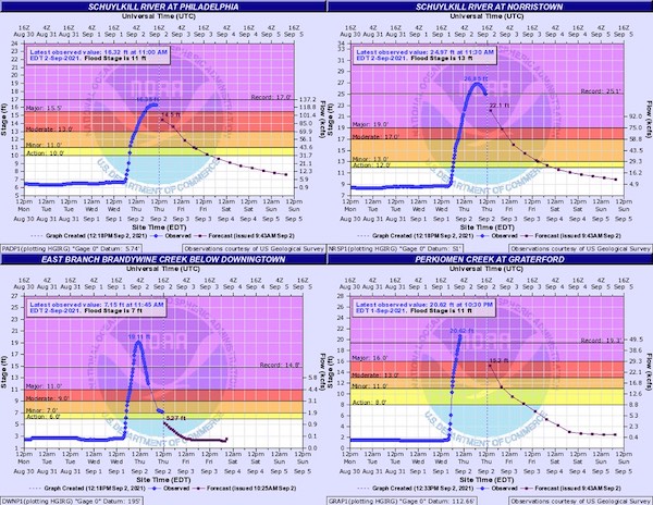
On Thursday morning, the Schuylkill River in central Philadelphia reached 16.35 feet, its highest level observed since the famed Saxby Gale storm of 1869. The East Branch of Brandywine Creek below Downington, Pennsylvania, crested an astonishing 29% higher (relative to a zero stage) than its previous record, set during Hurricane Floyd in 1999.
The New York Flood Threat Was Well Predicted
New York’s new governor, Kathy Hochul – forced to deal with every political leader’s nightmare, a weather disaster, after just one week in office – called the rain “far more than anyone expected.” In fact, despite many residents getting caught unaware, the potential for high-end flooding was amply predicted by the National Weather Service. A flash flood watch for the New York City area for Wednesday afternoon was issued by the local National Weather Service office an amazing 48 hours in advance: at 3 p.m. Monday. The watch warned that “widespread 3 to 5 inches of rain is forecast with locally higher amounts possible.”
By Tuesday afternoon, the NWS Weather Prediction Center had enclosed the New York area in a top-end high-risk area for flood-producing rains for Day 2, Wednesday. The Weather Prediction Center also noted that some locations had a 95% chance of seeing rainfall amounts that would be expected once a century or less.
This looks more like a subway car wash than a subway station. This flooding has to be doing an incredible amount of damage to the NYC subway system. pic.twitter.com/bgtMbjiHvM
— Mike Saccone (@mikesacconetv) September 2, 2021
It’s possible that distractions from other major news events pulled the focus away, or that users who rely mainly on icon-based depictions or brief messages from apps rather than narrative detail may not have grasped the extreme nature of the flood threat. Moreover, if residents of New York had heard only that “remnants of Ida” were approaching, they might not have seen the situation as being especially worrisome, especially after multiple flood events already this summer. Perhaps it’s time to reconsider how top-end flood threats are depicted and disseminated to an audience that may be inured to them.
Damage from Wednesday’s Flooding: Sure to be Monumental
It was painfully clear even on Wednesday night that floodwaters affected a vast part of New York and its infrastructure: cascading through subway tunnels, flooding countless streets and garden-level apartments, and covering the ground floor of Terminal B at the Newark Airport.
“It’s going to take a long while to count the cost for all of the damage to property, infrastructure, vehicles, and other facilities,” said Steve Bowen, head of catastrophe insight at Aon. “Ida’s impact across the South was already going to run deep into the billions, but there is no question that the flood and convective storm damage in the Northeast is going to add direct financial loss costs with many zeroes to the final total.”
He added, “This will go down as one of the greatest forecasting success stories for several branches of NOAA: the National Hurricane Center, National Weather Service, Weather Prediction Center, and Storm Prediction Center. Given the impacts to life and property, I wish they’d been wrong.”
The Unmissable Fingerprints of Climate Change
The phrase “climate crisis” feels ominously apt when staring at an event like Wednesday’s titanic flood. For more than 20 years, a steadily growing body of research has found that the most intense U.S. downpours are getting more intense, particularly in the Northeast, as a result of human-produced greenhouse gases. This trend is only projected to get even worse.
Air “holds” about 4% more moisture for every 1 degree Fahrenheit (0.55 Celsius) increase in temperature. Air above the oceans has about 10% more moisture compared to 1970 because of the increase in global temperatures. This extra moisture leads to about a 10% increase in heavy rain as storms gather the excess moisture.
Ten percent may not sound like much, but when that extra moisture condenses inside the storms, it releases additional heat energy known as latent heat, which is the energy that was required to change the phase of water from liquid to gas during the evaporation process. That extra heat energy enlivens the updrafts and makes the storms more intense, allowing them to gather in moisture from a wider area and last longer. This phenomenon can lead to a 30% increase in rainfall, as has been documented in several cases of major flooding (e.g., this case in Colorado in 2013).
Our infrastructure is not ready for climate change, a thread from tonight. 28th St. subway station pic.twitter.com/uYemJKB8yg
— Brian Kahn (@blkahn) September 2, 2021
Our nation’s increasingly wobbly infrastructure is in a precarious position to handle the storms being delivered today, never mind tomorrow. Although the post-Katrina bolstering of the New Orleans levees helped keep the city from flooding during Ida’s landfall, many other parts of southeast Louisiana fared far worse. What’s more, a huge regional power outage is causing immense suffering, forcing many thousands to leave town or to avoid coming back for days that could turn into weeks.
The IPCC’s Sixth Assessment Report, released in August, sounds a clarion call to pay more attention to compound threats, such as the juxtaposition of heat and drought or river and storm-surge flooding that will likely be worsened by climate change. For a sense of how an entirely plausible series of climate-fueled disasters could escalate into a full-on global food crisis, see the op-ed by Jeff Masters published on Wednesday in The Hill.

Something I never thought I would have to see in my lifetime living in the Northeast, A multi vortex wedge tornado. Burlington Township NJ from earlier today.
(credit: Geo Jimenez via Facebook) pic.twitter.com/izlTbPS5g9
— Mike Stanislaw (RT Front Quadrant survivor) (@mikestanislaw) September 2, 2021
A Cluster of Spectacular, Scary Tornadoes Prowls the Mid-Atlantic
The juxtaposition of warm, moist tropical air, upper-level energy, and substantial wind shear enhanced by ex-Ida led to an outbreak of highly visible and damaging tornadoes on Wednesday afternoon. Several supercells behaved more like Great Plains storms, rotating like mad and dropping twister after twister. One tornado left considerable damage in Annapolis, Maryland, and several others pockmarked the landscape of the outer Philadelphia suburbs.
As of Thursday morning, the Storm Prediction Center had identified five tornadoes associated with Ida on Wednesday and 11 others on Sunday and Monday. This ranks far below the record 120-tornado outbreak triggered by Hurricane Ivan on Sept. 15-18, 2004. Still, the visibility and apparent intensity of Wednesday’s tornadoes were startling.
Some of the damage this morning from the tornado in Mullica Hill, NJ #ida pic.twitter.com/Yb75vnEXUg
— Jen Carfagno (@JenCarfagno) September 2, 2021
Some of the most severe damage was reported in Mullica Hill, New Jersey, about 20 miles south of Philadelphia, where an unusually visible tornado was widely videotaped. In one neighborhood, large homes were partially or completely destroyed over several blocks.
“That storm was a classic supercell, and the tornado had inflow vortices that I’ve only seen associated with strong and violent tornadoes. I’ve never seen that kind of behavior documented in the northeast U.S.” said James LaDue (NWS Warning Decision Training Division), who is co-chairing a committee to update the Enhanced Fujita Scale.
As the tornadic storms streamed into the frontal zone east of ex-Ida where the most intense rainfall was occurring, forecasters confronted a classic dilemma: the need to issue flash flood warnings and tornado warnings for the same area. This combination happens more often than one might think. A 2015 study led by Erik Nielsen, now at Texas A&M University, examined overlapping tornado and flash flood warnings, defined as tornado and flash flood warnings within 30 minutes of each other at the same locations. They found 2,800 overlaps in the period from 2008 to 2014.
“This number is higher than the authors expected and highlights the nonnegligible frequency of these dangerous situations in public dissemination,” Nielsen and colleagues wrote.
In Bucks County, Pennsylvania, Wednesday’s events produced a rare juxtaposition of a flash flood emergency and a tornado emergency. Only a handful of cases have seen these emergency-level warnings issued for the same county at the same time. The “emergency” designation, first used for tornadoes in 1999, highlights when catastrophic damage and/or a severe threat to human life is imminent or ongoing.

Larry Becomes a Hurricane
The fifth hurricane of this extremely active 2021 Atlantic hurricane season is Hurricane Larry. At 11 a.m. EDT Thursday, Larry was located in the eastern tropical Atlantic, far from any land area. Larry was headed west at 17 mph and had top sustained winds of 80 mph. Satellite images showed that Larry was a large hurricane with impressive low-level spiral banding and improving upper-level outflow.
Larry will be in a favorable environment for strengthening over the next three days, and the National Hurricane Center and most of the top intensity models are predicting that Larry will become a major hurricane by Saturday. Early next week, Larry may encounter higher wind shear and some dry air, which may preclude further intensification.
Larry will be steered to the west to west-northwest by the Azores-Bermuda High through Friday but is predicted to angle more to the northwest this weekend, when the hurricane feels the pull of a trough of low pressure passing to the north. For the time being, the long-range Euro and GFS ensembles are emphatic on an overall recurvature to the north and northeast away from North America, as a strong upper-level trough is likely to set up on the U.S. East Coast next week. However, it is possible that Larry will angle far enough northwest to affect Bermuda on Thursday, September 9, and/or Newfoundland, Canada on Friday, September 10.
If nothing else, we can expect Larry to churn for days as a strong hurricane in the open Atlantic, generating large swells that will bring high surf and the risk of rip currents to the U.S. East Coast, Canadian Maritime Provinces, and north-facing shores of the Caribbean islands next week. Larry’s expected longevity will also bulk up this season’s total accumulated cyclone energy.
Disturbance 91L Brings Heavy Rains to Central America
In the southwest Caribbean, an area of disturbed weather designated 91L has moved inland over northern Nicaragua and was bringing heavy rains to northeast Nicaragua and northeast Honduras on Thursday afternoon, as seen on satellite imagery.
91L was moving west-northwest to northwest at about 5-10 mph, and close proximity to land will inhibit development over the next few days. The disturbance is predicted to cross the Yucatan Peninsula and enter the southwestern Gulf of Mexico by Sunday. Though waters are warm there, 91L is expected to experience high wind shear, making development difficult. In its 8 a.m. EDT Thursday Tropical Weather Outlook, the NHC gave the system 2-day and 5-day odds of development of 10% and 20%, respectively.
New Disturbance Off the Coast of Africa May Develop
An area of low pressure that developed off the coast of Africa about 300 miles east-southeast of the Cabo Verde Islands (see lower right of Figure 5 above) was moving west at 15 mph. Satellite imagery indicated that the disturbance was showing signs of organization, with a modest-sized region of heavy thunderstorms that were beginning to rotate. By Friday, however, the disturbance is predicted to move into a region with higher wind shear caused by the upper-level outflow from Hurricane Larry. The disturbance will also be over cooler waters, and this will make further development slow. This system has low model support for development. In a special 11 a.m. EDT Thursday Tropical Weather Outlook, the National Hurricane Center gave the system 2-day and 5-day odds of development of 30%. The next name on the Atlantic list of storms is Mindy.
How To Help Hurricane Recovery Efforts
The Partnership for Inclusive Disaster Strategies (formerly portlight.org), co-founded by members of the Weather Underground community, is responding to the Hurricane Ida disaster. Also, the Weather Channel has put together a list of many excellent charities that will be active in Hurricane Ida recovery.


I live in Montgomery County, PA (suburban Philly), and certainly never expected to shelter in my basement for a tornado warning, (which hit down the road) but here we are. I’m lucky and grateful to live near a school, and its open sports fields absorbed a lot of water. For cities, density and an infrastructure well past its prime portend a grim future. The clucking sound is chickens coming home to roost.
I work in Center City, and a couple years ago, a century-old water main burst on Sansom Street, and that afternoon there were Class 2 rapids in a major American City. Nearby businesses were forced to close, and the street blocked for over a year.
The Vine Street Expressway in downtown Philadelphia (I-676) is now a river. It’s normally a road not a body of water. A tornado hit about 1 to 2 miles from where I live in Upper Dublin specifically the Fort Washington section. I luckily had no damage. The roads there are still unpassable for variety of reasons.
https://billypenn.com/2021/09/02/photos-and-videos-of-the-flooded-highway-in-the-middle-of-philadelphia/
That massive tornado hit right at the foot of the Burlington Bristol Bridge (NJ side) which is three miles from my work, and four from my wife’s. NJ is NOT known for tornados, let alone giant ones.
We also got two alerts saying “go to your basement NOW.”
The bridge is about fifteen miles north of my home, Mullica Hill (where the homes were destroyed), is about fifteen south.
I recall other tornadoes in NJ, in particular one about 2003 near Princeton. It does happen from time to time.
This looks a lot like hurricane season to we Sothrons. It’s a real nail biter when strong storm systems approach. Experience gained from previous episodes of “heavy weather” is the biggest predictor of safe personal outcomes. (After Hurricane Katrina we made a conscious choice to move away from the Gulf Coast.)
As New York City has shown yet again, the entire American seaboard is now squarely in the “danger zone.” I don’t envy the people living near any coast in the Northeast.
Secondly, what does this tell us about the strength and prevalence of winter blizzards? I seem to recall that this past winter had some ‘curious’ temperature and snowfall patterns in North America.
Finally, what about FEMA? Have they been “drowned in a bathtub” yet?
Welcome to the “New World Climate Order.”
You are much more in the deep South than here, here being just a bit south of Asheville, NC and officially we are in the Upstate SC. Few weeks back there was an afternoon of tornado warnings that were fluid (later turning into a watch). Fortunately for me and mine, nothing hit but there were smaller touchdowns some 20 to 40 miles south from me.
I’d thought leaving Plano and north TX, I would be clear of the tornado activities. Not so much.
From my vantage point in the northeast, I don’t envy anyone in a place subject to increasingly frequent mega droughts and concurrent fires and dust bowls. Better too much water.
I’ll admit to having a bit of ‘waterlust’ watching videos of oh so much.
The last time I went to California, there was a mega-drought + mega-wildfires. Amazingly the fires’ smoke blew east, completely avoiding where I was and followed me all the way back to New England where the ash lit up the evening sky.
In honor of that, I offer this completely original rhyme:
Red sky at night/
California’s alight
Oh, to be a sailor of the Empire!
“Red sky at morning,”
“Republicrats take warning.”
I think that something ‘fun’ could be done with Coleridge’s “Kubla Khan.”
The entire marine conceit is fruitfull; chock ablock with gooey gargantuan good-thinking-ness.
This was not a coastal event. To me, the important learning from this event (hurricane Ida flash flooding NY/NJ/CT/PA) is that people who live a fair good distance from the coast (western NJ/eastern PA) can and did suffer the consequence of climate change due to global warming. No one is safe from the effects of climate change. No one. We are all going to suffer loss of property and possibly life years because we cannot work together with resolve to do what needs doing.
Much of Eastern PA and essentially all of New Jersey is within 50 miles of the ocean.
Larry is on the way, perhaps:
https://www.nhc.noaa.gov/graphics_at2.shtml?start#contents
This is the beginning, we will see increasingly extreme weather events as time goes by and neither our infrastructure nor our political system is capable of dealing with these issues.
Necessity is the mother of invention. When it gets dire enough we may see some competence finally, or else watch society dry up or wash away. I’m sure the military folks will not be pleased when they are forced to admit that these issues are a larger threat than the poppy farmers on the other side of the planet. These fatigued bozos are a clown show with their boots on their head. I say we make them all work in construction like I used to do.
The US Senate was briefed on climate change by a world expert in 1988. And since then – it’s done NOTHING. Mostly thanks to the efforts of the Koch brothers who spent who knows how many millions to convince people climate change was not.
Our country is still debating climate change as we get well into climate disaster.
We’ve been well and truly Koched by a bunch of billionaire brothers out get richer.
Five years from now there will be guided tours to piss on their graves when people realize just how bad we’re $crewed.
I grew up in Chester County, PA. The Westtown Road and Chateau Drive photo shown in this link? I know that area very well.
https://www.fireengineering.com/news/hurricane-idas-remnants-hit-northeast-us-at-least-eight-dead/
Hoping that all of my PA peeps are okay.
And of course, the answer isn’t to de-populate these climate disaster prone areas, but to upgrade the “infrastructure” to deal with it by throwing more e-money and fossil fuels at it. But hey, if you keep doubling down at the blackjack table, eventually you hit, amirite?
Climate change will pull all the Aces from the deck. You’ll likely go Bust before the Dealer.
Every four years, the American Society of Civil Engineers give a Report Card for America’s Infrastructure and I bet you know what grades are given. America’s infrastructure has been run down for decades now but whether is was deliberate or just through neglect, I cannot say. But what this means is that this is the infrastructure that is being slammed by climate change which is right here and right now. To quote a line from the late, unlamented Donald Rumsfeld, ‘You deal with climate change with the infrastructure you have, not the infrastructure you might want or wish to have at a later time.’
So what are they doing about it? Not a lot from what I see. They want to give the Pentagon $1.2 trillion over the next decades as they are so impoverished and they want to spend another trillion and more upgrading nukes which were last used for real way back in 1945. And don’t talk about the present infrastructure bill as it is merely a down payment and may be a disguised way to hand over public assets to corporations for fun & profits.
It may be that nothing will change until there is more floods and tornadoes like just seen this week. But in Washington DC with the Senate and House in session so that instead of MAGA rioters assaulting the Capitol Building it will be flood waters lapping the stairs instead. That is what it took in the 1930s to deal with the Dust Bowl. They were in session when the sky went dark with the dust blown from places like Oklahoma and the legislators became true believers – or else.
https://infrastructurereportcard.org/
I don’t expect any changes, even with more floods and tornadoes. The requires a competent government, which we don’t have. Add evidenced by covid and the government response.
Perhaps reality-based global warming accepters could figure out how to conquer smaller levels of government in places where they are the overwhelming majority. And then use their conquered governments to facilitiate Separate Survival in the Reality-based Green Zones.
And let Darwin take the rest.
What are we doing about it?
The answer is more drilling for fossil fuels. Biden is stepping up the leasing of more drilling sites on federal land and also in the Gulf of Mexico. In addition, Biden was is in agreement with Trump in opening up Alaska’s North Slope to drilling but a federal judge has blocked that project. It is expected that the Biden administration will appeal. To be fair Biden is no worse than the presidents who proceeded him. Obama, while signing the Paris Climate Accord, also stimulated the oil business of which he bragged about while speaking at an oil company convention telling the attendees that ” that now we’re drilling everywhere.” Of course, Bush and Trump also gave the oil companies everything they wanted. It is obvious that any plan to combat global warming won’t happen unless the oil companies approve. That may be why the Biden approach to climate change is centered on carbon capture, a technology that is not yet proven. With carbon capture, the fossil fuel industry can keep expanding drilling while carbon capture would reduce CO2 concentration. That is the hope.
I agree that nothing is being done likely because if the necessary step was taken to remove oil out of the equation, the world as we have known it ceases to exist. And without a contingent plan to address this gone missing economic prowess, it very much will collapse any and all economies on a scale the world rapidly becomes uncivilized. That is the pain that absolutely needs to happen but hardly a leader exists with the gumption to administer the first step toward this or any other hurt.
It is the same with the misdiagnosis of today’s economy. The fed and QE happens to support the over spending every member of congress endorses year after year. You take that away and you have the hurt of observing up front globally a bankrupt entity without salvation. Somewhat of a real time Thelma and Louise moment.
This over coddling has not prepared us for the hurt needed to repair our planet even though the frustration of seeing our fragile atmosphere being destroyed by every one of us is evident most everywhere you look.
And who is going to be the person to say “that’s it, drive your ICE auto to this location and have it crushed, no more air travel, plastic, rubber, etc. we’re done”. Even though that is exactly what needs to happen.
See Mark Z Jacobson (Stanford prof.) on Carbon Capture. He proves that the carbon released during the process is greater than the amount captured. Carbon Capture is another way to spend money, increase Greenhouse Gasses making somebody rich at the expense of the taxpayer. It’s a catchword that sounds good and is completely a lie.
Why build infrastructure here when a good chunk of our manufacturing has gone overseas. We just don’t need as much as before.
That sounds like weary surrender to the prospect of a permanent Free Trade future.
If we were to abolish Free Trade and restore Protectionism, we might be able to rebuild a small shadow of our former industrial ecosystem, and then we might need some infrastructure.
A collection of photos and videos from the flooding in Philadephia.
https://billypenn.com/2021/09/02/photos-and-videos-of-the-flooded-highway-in-the-middle-of-philadelphia/
Those are remarkable photos depicting a downtown river feature instead of a thoroughfare for transportation. Closest I recall to a similar catastrophic flooding scenario were portions of Rocky Mount, NC flooding just off the exits from US 64. The overpass of one intersection in particular I recall, where like a Lowe’s hardware, a gas station and an IHOP were basically covered up or nearly so.
Back in 1999, I think it was.
All those flooded cars will appear on used lots given high prices. Caveat emptor.
Yes, climate change is going to have immediate AND lingering impacts. Here is a link to the likely negative impacts to the water quality at Lake Tahoe AFTER the flames are doused: https://www.latimes.com/california/story/2021-09-03/caldor-fire-smoke-and-ash-are-clouding-lake-tahoes-famously-clear-water
Similarly the flush of Ida’s polluted urban storm runoff on the East Coast into the streams and rivers, and eventually the Atlantic, will likely negatively impact freshwater and marine ecosystems.
Here’s a quote from an LATimes editorial about climate change:
(emphasis mine—actually, Yves’)
In Connecticut, hurricanes are nothing new (see 1955 Connecticut floods) but ever since Hurricane Sandy we have been taken aback by the severity of (not even hurricanes) the tropical storms making their way up here from southern climes. It seems most have let the weather events in Europe earlier this summer go into the memory hole, and Tennessee? “What, what happened down there?” Until it hits one directly, it is spectator sport. Wait until the Gold Coast (Connecticut) gets whacked. When we see a Cat 3 storm roll in, we will know for sure we are in trouble (Cat 2 is about as strong as they get here, with few exceptions.) But you know, even then…
Local news coverage has been uniformly shoddy, with the same 10-15 minutes of footage broadcast ad infinitum. But this time, watching NYC news over the rooftop TV antenna, I have never seen so many graphic cellphone videos of cellar apartments flooded with raw sewage, and streets also showing huge amounts of turds floating, with the addition of adorable rats doing their thing in the floodwaters. This spells disease to me, so I am more than worried about things to come. Of course, many reassuring voices sooth us with the thought that fortunately these are once in 500 or 100 year events. And the cars: thousands submerged that can never be repaired… isn’t this almost as bad as losing your house if you are not well off, and can’t get to work? Public transportation here is much like the rest of the country — not so hot.
How close is the breaking point? This is peak hurricane season here in New England, for about another month, so keep watching. I am on high ground, but surrounded by large, tall trees that would cost about a million dollars to clear. So I pay attention.
Most of the people of Connecticutt already know about man made global warming. They don’t need any more educational storms.
If we are going to wish for more educational storms, we should wish them to happen where the people still need educating.
Like . . . . a Cat 6 or Cat 7 hurricane which parks itself in place over Dallas-Fort Worth and along with the wind, brings a Harvey dayload of rain for seven days in a row.
Or an F6 or F7 tornado over whatever city in Oklahoma supports the oil industry the strongest. An F7 tornado full of beachball-sized hailstones traveling at 200 mph. And stays parked in place over Pro Oil City long enough to raze it to the ground and smooth the ground off and remove all analyzable biological traces of any people ever having been there.
Would that educate Senator Inhofe?
How about a little F7 tornado parked over Senator Manchin’s own personal house?
Maybe some 6 inch ice storms all over the Tar Dreck Mines of Alberta?
Yes, everybody here knows of course especially as they notice events speeding up, however we still have our 42% idiots, and sum up many of the rest as “Everybody wants to go to heaven but nobody wants to die”
Cat 6 and 7… now I’m wondering how long until.
Here is the official Saffir-Simpson hurricane wind scale- number designator chart.
https://www.nhc.noaa.gov/aboutsshws.php
I figured out how much mph-increase it took to get from one category to the next category. Each interval is a different size. ( I don’t know why). The average of the 4 intervals is 19.7 mph. Its easier to call that average size interval to be 20mph.
So if the average size or length of the speed-increase-interval it takes to go from one category of hurricane to another is 20mph, then it would be more honest and informative of the weather services to just keep adding more Hurricane Categories as the sustained wind speed rises by 20mph intervals.
So if 157 mph is the windspeed which gets a Hurricane just barely called Category 5, then if a hurricane has a windspeed of 178mph, it should be called Category 6, and if a hurricane has a windspeed of 199mph it should be called Category 7, and if a hurricane has a windspeed of 220mph it should be called Category 8, and so on up by additional 20mph increase increments.
If we had granular windspeed increment honesty in assigning Categories to hurricanes, we would already realize that we have already had some Category 6 hurricanes, if the weather services were to practice truth-in-hurricane-category-increase assignment by equal speed increments.
We have already had 8 measured Atlantic hurricanes at or over 178 mph. If we had “truth in category assigning”, those would be designated as Category 6 hurricanes. So we already know what a Category 6 hurricane looks like, because we have already had 6 of them. But until the weather services decide to practice truth-in-categorizing hurricanes, we will not be able to have a fully nomenclaturally correct discussion of hurricanes.
Here is a website with lots of words, but also offering a chart of the strongest Atlantic hurricanes.
https://www.insider.com/strongest-atlantic-hurricanes-in-history-by-wind-speed-2020-8
8 of them were over the threshhold windspeed of 178 mph which would get a hurricane called Category 6 if we ever had truth-in-categorizing high-end hurricanes. I hope we ever get that someday.
And Typhoon Nancy, which reached sustained windspeed of 213 mph in the pacific some years ago, would be Category 7 and just short of reaching Category 8 by 8 more mph.
If we had truth-in-category-designating at the high end.
You read my mind… I know typhoons are different, but hasn’t there been a number of extremely powerful storms in the Pacific etc. in the last several years? Truth in advertising… and I wonder if the shoddy, kinda boring and repetitive coverage was not “Let’s move on folks, lots of other stuff to watch on tv” instead of the endless coverage we got all the time a few years ago even though the eyes attracted sold ads. And now I’m scared of the weather, hoping stuff like Ida doesn’t happen in the winter here.
People should practice seeing animated charts, maps, graphs, diagrams in their own minds. When they get good at that, they might start imagining what could happen if “this”, “that” and “the other thing” all come together at the same place and time.
What if you had a super-hot Gulfa Mexico blasting steam into the air above? And that river of steam moves north to meet and grind alongside of a mass of super-cold arctic air surging south? Imagine an ice storm with Ida remnants-worth of water involved. How many house and building roofs could hold the weight of an 8 inch thick layer of ice, for example? Not to mention the difficulty of getting around with everything locked in the same 8 inch layer of ice. Plus, how many power lines and towers would come down under 8 inches of ice?
Interesting future to try preparing for.
This is from the linked article about the energy sector in Louisiana:
“The facility is undergoing a $1.5 billion expansion, part of the continued expansion of Louisiana’s fossil fuel infrastructure.”
May I suggest that relocation to higher ground instead of expansion would be wiser? The same goes for the Houston area.
Maybe expansion in place is just what is needed so that the oil industry gets shrunken down when the expansion in place goes under water.
My worry is that, when the sea level rises to cover the coastal infrastructure, we will see “dead zones” of immense sizes. Dead zones in exactly those places where the living things of the sea usually live and spawn. I don’t even want to think about the mutagenic properties of many industrial chemicals.
If you like certain kinds of canned fish, maybe now is the time to lay in a few couple-hundred cans of tuna, sardines, pink salmon, Riga sprats, kippered herring, etc.
New nomenclature? Maybe . . . raindump waterbomb.
For 12 inches or more rainfall per day . . . . a new unit . . . . the Harvey dayload. ” We had a Harvey dayload of rain today and we expect a Harvey dayload of rain tomorrow.
Tornado and hurricane strength scales should not stop at their current cinder-block “top”. The interval between every tornado strength between F1 and F5 should be made open ended. If the tornado is a “whole interval” stronger than the threshhold for F5, call it F6. Then F7. Then F8. That would allow for more granular information about the tornado strength at the high end.
And hurricanes should not stop at Cat 5. Every further equal interval of wind-speed reached should merit another Cat number. So . . . Cat 6, Cat 7, Cat 8, etc. That way, weather people would not have to speak of ” mild Category 5, category 5, strong category 5, extreme Category 5, etc.” and other such meaningless information-concealing terms for the new and improved high end hurricanes to come.
Just found a tweet by Eric Feigl-Ding that talks about those people in New York that lost their lives in cellars-
‘‘Subterranean dwellings’ are cellars, not basement apartments. Cellars’ heights are 50%+ below finished grade. It should be explicit that bc of the lack of affordable housing people resort to living in cellars & in the event of a fire or flood they are trapped without any egress.’
https://twitter.com/oddments_sundry/status/1433614093194301446
With explanatory illustration.
I think the impact of climate change as far as having major impact how Americans plan for life is still many years in the future . The only thing that has restrained an expansion of gasoline-powered personal vehicles is a current chip shortage. Single-family housing is as popular (or even more) as ever. I don’t read about Dallas area losing population because the growth is in suburbs 40 miles from downtown. Accept that energy use patterns are pretty change-resistant and work from that. Want to move away from liquid hydrocarbon fueled ground transportation for a net reduction of carbon dioxide? Nuclear power plants + better EVs and if that takes another 15 years to find its feet, well do not get worked up about it. My best guess is that in the 2040s the world will fund a mildly opaque solar shield for the earth, stationed out half a million miles (or where ever the optimal distance is for sizing and positioning). Maybe decades after that the shield will come down as better methods to control earth’s heat retention are found.
One hour north of NYC we have had 3 tornado warning from NW S during July-August. Luckily no tornadoes formed but the thunderstorms those nights were very intense. In August 2011 we had hurricane Irene. Eleven inches of rain fell in 24 hours. The floods washed out bridges and the Metro North train lines. Then in 2012 was Sandy.
But development has not changed. In NYC two very large projects are going ahead in Long Island City and Flushing Meadows. Both parts of Queens were flooded by Sandy.
ID A and Sandy flooded Newark Airport. Sandy flooded LaGuardia Airport. JFK Airport is only slightly higher in elevation.
I think there is no way those 3 vital pieces of aviation infrastructure can be saved. They are located next to the water and are only 4 to 6 feet above MSL.