“He is working on a more difficult problem.” — Albert Einstein, of his son, Hans Albert Einstein, a famous hydraulic engineering professor who developed important equations for sediment transport in rivers.
By Lambert Strether of Corrente.
Today’s post is about restoring naturally meandering streams in the Anthropocene, a topic that fits well with my tendency to perambulate through intriguing topics in the biosphere. And I won’t make jokes about A Sedimental Education, or “Market Sediment,” because I’m serious about my adulting. First, and with the soil fans among us in mind, I’ll look at how sediment is defined and classified. Then, I’ll summarize a scholarly controversy about stream restoration, which centers on the question: “Restore to what?” Finally, I’ll look at the “The Big Spring Run Project,” implemented by the winners (as I believe) of that controversy, which I think offers a lot of hope about what our streams (and “wetlands”) could become. (There is an enormous liternature on stream restoration, much of which is mandated by Federal anti-pollution requirements, and which also involves all the usual suspects, including real estate developers, Federal and state agencies, NIMBYs, environmental activists, and so on, as well as propertarianism as an ideology. My focus in this post will not be on those topics, but only on the substances, the sediment and the streams involved. However, if any readers have been involved in stream restoration, especially the permitting process, please speak up!)
So, let us wander over to the Oxford English Dictionary for a defintion:
sediment noun & verb. m16.
[ORIGIN: French sédiment or Latin sedimentum settling, from sedere sit: see -i-, -ment.]
A. noun.
1. Matter composed of particles that settle to the bottom of a liquid; dregs. m16.
B. verb.
2. verb intrans.
‣a Settle as sediment. e20.
‣b Of a liquid: deposit a sediment. m20.
(Sediment (“dregs”) is also what an Oxford don finds at the very bottom of his bottle of port, but as we shall see, river sediment can cover other soil, which is bad.)
The National Geographic is a bit more abstract:
Sediment is solid material that is moved and deposited in a new location. Sediment can consist of rocks and minerals, as well as the remains of plants and animals.
And the United States Geological Service (USGS) provides this definition and vivid description:
Rocks as small as tiny clay particles and larger that are moved by the water are called sediment. Fast-moving water can pick up, suspend, and move larger particles more easily than slow-moving waters. This is why rivers are more muddy-looking during storms—they are carrying a LOT more sediment than they carry during a low-flow period. In fact, so much sediment is carried during storms that over one-half of all the sediment moved during a year might be transported during a single storm period.
If you scoop up some muddy river water [musical interlude] in a glass you are viewing the suspended sediment in the water. If you leave your glass in a quiet spot for a while the sediment will start to settle to the bottom of the glass. The same thing happens in rivers in spots where the water is not moving so quickly—much of the suspended sediment falls to the stream bed to become bottom sediment (yes, mud). The sediment may build up on the bottom or it may get picked up and suspended again by swift-moving water to move further downstream.
(Our Oxford don might agree with the National Geographic, but certainly not with the USGS!)
This being geology, there is a classification scheme[1]. Again from the USGS:
Nomenclature describing sediment texture distributions is important to geologists and sedimentologists because grain size is the most basic attribute of sediments. Traditionally, geologists have divided sediments into four size fractions that include gravel, sand, silt, and clay, and classified these sediments based on ratios of the various proportions of the fractions. Definitions of the fractions have long been standardized to the grade scale described by Wentworth…
Here is the Wentworth scale:
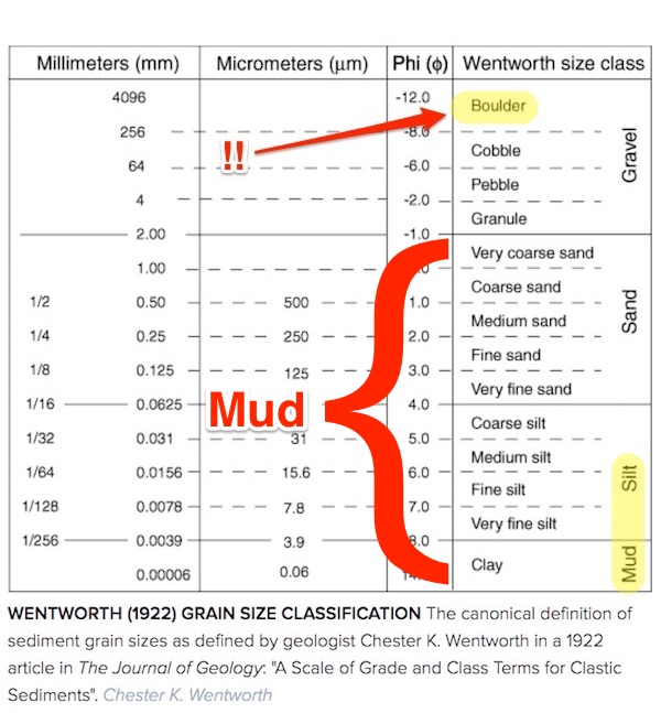
I think it’s very funny that boulders can be classified as sediment, although here our Oxford don’s dissent would become vehement. I added the highlight for mud, which aggregates particles of Wentworth sizes, and clay. Mud, too, has a definition:
Mud is defined as a mixture of mainly fine-grained sediments (clays, silt and sand), organic matter and water, where the cohesive properties of the clay fraction, enhanced by the properties of the organic matter, dominate the overall behaviour. Studies on erosion behaviour of sand-mud mixtures indicate that the bed exhibits cohesive behaviour for clay contents above 15-20%. In daily language “mud” refers to the deposited state of mud particles. In this state mud can occur as a fluid-like of soil-like entity. The dynamics of mud then refers to the formation, deformation and erosion of such layers.
(One recalls that if mud is thrown, it may stick. That’s why!) The formation of such layers is called sedimentation. From the Penn State Extension, “What is Sediment and Why is it a Stormwater Pollutant?“:[2]
Sediment can also blanket the stream bed in a process called sedimentation. Over time, this process of mud building up on the stream bottom can reduce viable habitat for aquatic insects, fish, amphibians, and other wildlife by clogging the spaces between larger gravel, cobble, and boulders. Overall, the population of more sensitive species will be reduced, leading to a less diverse aquatic community.
What we have here is sedimentation. From the The Big Spring Run Project:
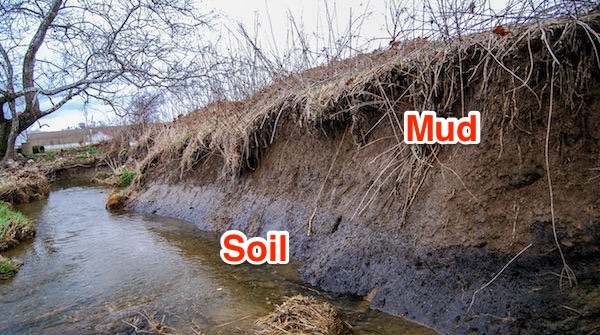
The photo caption:
Meters of mud had buried the rich, black soil (bottom layer) that typified Big Spring Run before Europeans arrived. The black soil contained seeds that revealed what plants had once grown along the stream.
That brings us tp the Big Spring Run project. The important question that the scientists doing real science asked, for that project, was the origin of the layers that were built (not having been turned into rock) in historical, not geological, time. From this wonderful, heartening article in Science, “A secret hidden in centuries-old mud reveals a new way to save polluted rivers“:
Brown water might not hold much interest for many researchers. But a dozen years ago, it catapulted [geologists Robert Walter and Dorothy Merritts] to scientific prominence. The pair, professors at Franklin & Marshall College (F&M), showed that Big Spring Run and many other meandering, high-banked streams in the eastern United States look nothing like the low-banked, marshy waterways that existed when European explorers first arrived nearly 500 years ago. The original streams, Merritts and Walter argued in an influential 2008 paper published in Science, are now buried beneath millions of tons of “legacy sediment” that was released by colonial-era farming and logging, and then trapped behind countless dams built to power flour, timber, and textile mills. “We realized,” Walter says, “that the [streams] had been completely manufactured and altered.”
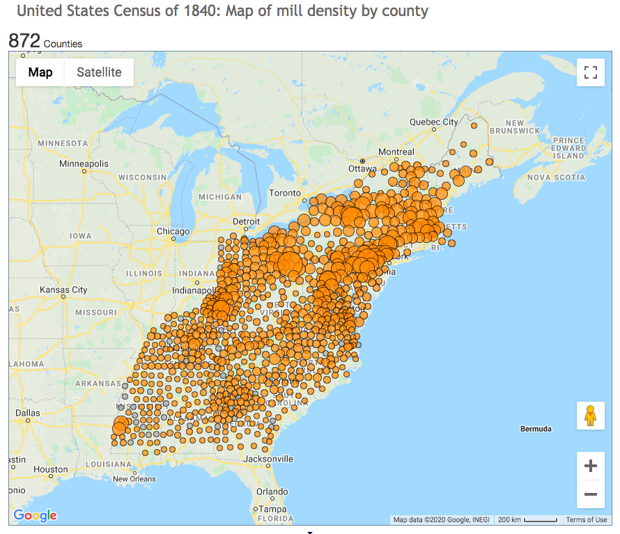
And there were rather a lot of those dams. Here is a map from The BSR Project:
So, if you’re going to “restore” Big Spring Run, you’d better restore it to its pre-colonial state. Back to Science:
The finding challenged decades of conventional scientific wisdom and sparked pushback from researchers who said the pair had overstated its case.
Walter and Merritts, in other words, initiated if not a “paradigm shift,” something beyond “normal science”. More from Science:
It called into question expensive efforts to restore rivers by using heavy equipment to resculpt them into what practitioners believed had been their natural shapes. And the work raised concerns that a massive, multibillion-dollar effort to clean up the nearby Chesapeake Bay would fail if planners didn’t figure out how to prevent massive slugs of legacy sediment, which also carries harmful nutrients, from sloshing down the bay’s many tributaries. “It was uncomfortable,” Merritts says, “because I knew that my colleagues had other ideas.”
New research is settling many of the debates that Merritts’s and Walter’s paper touched off. Although dams are not solely to blame for legacy sediment, it’s now clear colonial-era erosion did dramatically alter streams in much of the continent’s tectonically quiet eastern half, says Ellen Wohl, a geomorphologist at Colorado State University, Fort Collins. “There’s been an accelerated recognition of how ubiquitous this sediment is,” she says. And that recognition has been driven by Walter and Merritts, says Noah Snyder, a geomorphologist at Boston College. Their study is “one of the most influential papers I’ve seen.”
Now, the duo is hoping to inspire a new approach to stream restoration by turning back the clock at Big Spring Run. By removing centuries of mud, they have returned the stream to its marshy, precolonial glory, and are now demonstrating the environmental payoff such strategies can deliver.
So, they scraped off the top layer of mud and revealed the soil. With happy results. Again from Science:
As the debate swirled, Merritts and Walter decided to put their ideas into practice. During their research, they had met Joe Sweeney, a farmer who owned land that encompassed Big Spring Run, and Ward Oberholtzer, an engineer at LandStudies, a river restoration firm. Sweeney had hired Oberholtzer to examine why trees he had planted on Big Spring Run’s high banks to prevent erosion were dying. The conclusion: Their roots couldn’t reach the groundwater; trenches dug by Merritts, Walter, and their students suggested several meters of legacy sediment caked over the site. To restore such connections, the team proposed re-creating the kind of languid wetland that Walter and Merritts believed had once existed on the spot. But first they would monitor it for several years, to establish a baseline that could be used to evaluate any postrestoration changes.
In 2011, after more than 2 years of planning and assistance from the Pennsylvania Department of Environmental Protection, the National Science Foundation, the Environmental Protection Agency (EPA), USGS, and others, bulldozers began to remove 22,000 tons of legacy sediment along 4 square kilometers of the valley. (The silt was trucked to F&M and used as fill beneath a new building.) A layer of rich, black, precolonial soil emerged from beneath the legacy sediment. In it, researchers found seeds that provided an archive of the wetland plants that had once grown along the stream. Although federal regulations required the restoration team to carve a single new channel, they built low banks and installed stumps and other obstacles that would encourage high waters to jump the banks, transforming the stream into a multithreaded wetland.
Within 1 year, the banks bloomed with sedges like a Chia pet. Today, bog turtles scuttle and geese nest in thick native vegetation that has put down roots that hold sediment in place. There’s room for floodwaters to slow down and spread out, instead of sweeping away bankside trees and plants. “The biology does not have to re-establish itself” after every severe storm, Oberholtzer says.
Importantly, they monitored the process:
Monitoring shows the restoration has also altered the stream’s biogeochemistry. Storage of organic carbon tripled in the restored area and levels of nitrate, a key pollutant, dropped sharply, soaked up by the wetland plants. The load of sediment swept downstream from the restored area declined drastically, by 85%, according to a USGS report published this year. Polluting phosphorus, which hitches a ride on silt particles, dropped 79%. Ken Forshay, a research ecologist with EPA based in Ada, Oklahoma, says he was skeptical he’d see such improvements. But the data have “turned a nonbeliever into a believer,” he says.
Those data:
Even before all the results were in, the Big Spring Run project prompted similar restorations in Pennsylvania and Maryland, with 20 now completed and 10 more underway. It’s simple to see why: Though the project would have cost $1 million in today’s dollars to restore its 800 meters, it was at least 16 times more cost effective at reducing pollution than other techniques, found Patrick Fleming, an agricultural economist at F&M. “This practice blew the other ones away.”
Actual monitoring turns out to have been another novel aspect of the project. From Jeffrey L. Hartranft, Dorothy Merritts, Robert C. Walter, and Michael Rahnis note rather caustically in “The Big Spring Run Restoration Experiment: Policy, Geomorphology, and Aquatic Ecosystems in the Big Spring Run Watershed, Lancaster County, PA” (Sustain, Spring/Summer 2011):
The unglaciated mid-Atlantic region is a hotspot of stream restoration in terms of cost and number of projects (Bernhardt et al, 2005; Hassett et al, 2005), but the practice of aquatic ecosystem restoration has outpaced scientific investigation and our understanding of the full benefits (NRC, 2010). As noted by Palmer and Filoso (2009), stream restoration practices to date consist largely of “reshaping a channel and adding wood or rocks” [oof], but actual improvements to water quality or biodiversity are uncertain (Bernhardt et al, 2005; Palmer, 2009). Due to insufficient monitoring, it is difficult to assess most of these restorations. In the Chesapeake Bay watershed, for example, less than 6% of recent river restoration projects reported that monitoring occurred (Bernhardt et al, 2005; Hassett et al, 2005)
And from the same source, here is more data, married to an aesthetic outcome:
Since removal of historic sediment and construction of small, sinuous channels with low banks in late 2011, a multi-channel system has evolved with lower water depth, flow velocity, and boundary shear stress than the former incised single channel with high banks. Post-restoration monitoring indicates significant reduction in mean particle size of bed load in comparison to pre-restoration high-flow conditions. Analysis of sediment load data acquired over the past 4 years from 3 USGS gauge stations equipped with turbidity sensors both upstream and downstream of the study reach, along with repeat RTK-GPS cross section surveying, reveals a marked reduction erosion and increased retention of fine sediment within the restoration reach, decreasing the sediment load transported downstream.
A photo of the small, sinuous, meandering channels:
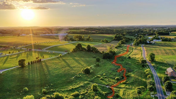
(The BSR Project also has an achingly beautiful drone video of Big Spring Run on its home page.) Honestly, the photo, with its golden haze, looks like an aerial shot of The Shire. Where are the hobbit holes with round doors?
Of course, the geology of Pennsylvania will not be the same as the geology of New England, or of the West, so “scraping off sedimentation built up by old dams” isn’t a panacea. Geology is hard! That is, I don’t want to inflict a heartwarming post on the readership, but I find the story of Big Spring Run project heartening. It’s a victory for science involving something very like a paradigm shift, others were persuaded by it, water get cleaner, and a river got more beautiful. Those are all good outcomes! One might wonder, metaphorically, how much more fertile soil would be revealed if other colonial deposits were removed…[3]
NOTES
[1] Chester K. Wentworth, “A Scale Of Grade And Class Terms For Clastic Sediments,” The Journal of Geology, Vol. 30, No. 5 (Jul. – Aug., 1922). “In no other science does the problem of terminology present so many difficulties as in geology.” Classification and ontology stans who have a free minute should enjoy reading this for the method. The prose is crystalline.
[2] Importantly (for funding) sediment, albeit in origin soil, is considered a pollutant. The Penn State Extension:
Once sediment reaches our waterways, it can degrade water quality in many ways. Small sediment particles may remain suspended in the water column or deposited onto the streambed. Suspended sediments increase the turbidity of the water, which causes the water to be cloudy, obstructs sunlight and limits photosynthesis of aquatic plants, reduces biologically available oxygen, and increases water temperature. Increased turbidity can also make it more difficult for fish gills to absorb oxygen and makes it harder for visual predators, such as brook trout or largemouth bass, to forage. Additionally, the cost of treating a source of drinking water with high levels of sediment is greater than the costs to treat clearer, cleaner water.
Sediment poses a greater water quality risk than just soil particles alone, because it often carries other pollutants, such as nutrients, heavy metals, organic chemicals, bacteria and other pathogens along with it. These pollutants originate from sources such as agriculture, industrial waste, mine spoils, and urban contaminants and can have short-term and long-term effects. Some will be dissolved into the water and washed downstream quickly, while others may remain stuck to sediment on the bottom of the stream bed for years.
[3] Readers: “My sediments exactly!”


What a great story. It cheered me up considerably. Habitat for nesting geese seems like a good result. Any other impacts on bird populations? Wetlands are such a wonder. Magic happens.
Yup, seconded – it always cheers me up to see stuff like this, and to realize that when people *care* and *do*, Mother Nature *can* recover and thrive.
My brother participated for several decades in various central and eastern oregon streamside habitat restoration projects, mainly on private property of ranchers w/active grazing herds. It was heartening to see 2 groups: environmentalists, and ranchers, work *together* (literally – all of them sweating together under the hot sun!) …and be happy that it was win-win for both groups.
The prime change was fencing vast lengths of creeks and streams (some that had no longer become year-round due to evaporation), enclosed areas for cattle watering away from riparian zones, and also a certain amount of re-planting w/willows and other native trees, brush and shrubs for shade.
Ranchers had substantial and dramatic increases in just a few years after the work was done in the form of increased stream flow (in many cases returning to year-round), grass in meadows expanding and thriving longer in hot weather due to increased water table/moisture flow, and overall habitat improvment & diversity — not just in stuff for cattle, but in native species.
Environmentalists enjoyed both the increased native species changes, as well as a side benefit of increased respect of the ‘locals’ (political capital spent in other restoration and environmental projects now supported by more people)
And both sides had many great barbeques after the work was done, enjoying food, swapping stories, and being *together* rather then political enemies. As it should be.
This isn’t a project he worked on, but is an example of recent work at Whychus Creek near Bend, OR:
https://www.youtube.com/watch?v=kN7XG89WTyo
& time lapse
https://www.youtube.com/watch?v=aIS-8A699f4
I agree. Needed a Mother Earth hug today. So what Judith & JiT said.
Great post!!
As an engineer who occasionally deals with stream restoration, it has been very frustrating about the lack of knowledge and expertise that the approving regulators have.
I worked on one about a decade ago and was unaware of the Walter and Merritts paper at that time, but I and a hydraulics engineer understood what made sense for a particular site. The agencies kept demanding “MORE SINUOSITY” in a manner similar to Christopher Walken’s great SNL sketch demanding “More Cowbell”. In the end, we presented three sinuosities – the one we wanted, one with more, but still acceptable, sinuosity, and another one that in the words of the engineer that developed it “so excessive, that nobody would ever want it”. Guess which one the regulators picked.
They then demanded a bank design that was guaranteed to create sloughing and sediment because it matched the stream model that Walter and Merritts disproved (I saw that paper a year after the restoration was built). They then demanded lots of fixes to the banks once the predicted sloughing occurred.
It is possible to do some excellent stream and wetland restoration, even in urban areas. but it is a struggle to get it approved through the regulators.
Interesting factoid – it is believed that a significant percentage of insect food for fish in streams and small lakes is actually terrestrial insects falling off of trees and shrubs along the water line. So simply planting native trees and shrubs along the water can greatly improve fish habitat by providing shade, shelter, and food. Limbs off those trees will provide woody debris over time. The initial woody debris is in there just to bide time until the excosystem restoration can supply it years later. Putting some decent sized rocks in streams creates hydraulic refuge locations for fish to hide behind in the stream flows.
Several major things have happened to reduce new sedimentation:
1. Much of the old sediments in these mill ponds came from when every nook and cranny of the east coast was logges and farmed in the 1700s-1800s. There was lots of sediment created that was then stored in the mill ponds and other low lying areas. Many of the old farm land has returned to forest or is subdivision (this is why there are a lot of stone walls in eastern forests). Preventing the old stored sediment from escaping quickly is key to protecting the estuaries.
2. In 1987 USEPA began to regulate stormwater and sediment discharges from construciton sites. That eliminated a major source of sediment to rivers, lakes, and estuaries.
3. 1972 Clean Water Act eliminated a lot of nutrients from municipal waste water systems over the past 40 years. That has greatly improved water quality.
Major things that still need to be done.
1. Point source solution from septic systems, especially second homes on lakes and rivers. Many are failing or inadequate. Very little policing of it. Major issue on recreational lakes and rivers and Lake Okechobee. This is a major cause of blue-green algae blooms in recreational lakes and streams.
2. Agricultural runoff with sediment and nutrients. This is probably the single biggest cause of blue-green algae outbreaks. Fierce voting block, so unlikely to improve soon.
3. Mountain-top coal mining stream protection rule just got eliminated by Trump, so mountain-top coal mining can deliver sediment and acid mining drainage to its heart’s delight.
For #2 – Agricultural runoff with sediment and nutrients – are you aware of any new cutting-edge/innovative work along those lines? Or also of old-fashioned, but still effective ways of mitigating?
That’s something that interests me, coming from a farming/fishing family. I’m not a hydrologist or engineer or anything like that though. Oregon/Washington (particularly the wetter west side) tend to have far more of the populations – farmers/ranchers/landowners as well – in the environmentally-conscious category, but man…the ‘fierce voting block’ is so true,
To a large extent, the new cutting edge approaches are old. Crop rotation, fallow fields, maintaining wetlands. Sediment these days is less of an issue than nutrients. After the Dust Bowl there were a lot of advances in how to till fields to reduce direct erosion. However, the modern use of glyphosphate and other herbicides in conjunction with GMO seed does mean that there are fewer other plants in a field that can help keep soil in place.
Modern industrial agriculture, especially ethanol corn and soy, is very focused on single crops in repeated plantings, so they are much more dependent on fertilizer because nutrients have not been replaced by crop rotation and fallow practices. Some percentage of that fertilizer is then washed off the land in rainstorms.
I understand about the potential for regulatory over-reach, but the battle over maintaining wetlands and natural drainageways is critical to protecting lakes and estuaries. “Inefficient” drainage through vegetated ditches, wetlands, vernal pools, and small ponds reduces the speed and quantity of water that flows to the large receiving water bodies and reduces the nutrients that get there as well. More water is infiltrated into the ground to help maintain groudnwater aquifers.
Industrial animal production has massive manure pits. Spillage from these as well as infiltration into groundwater is anotehr major source of nutrients. Flooding events are particularly devestating when these pits get flooded, because they are now directly connected to receiving water bodies. There has been massive pushback about serious regulation of these.
It is largely about maximizing short-term revenue and profits over understanding long-term sustainable sustainable agricultural practices.The technologies are available to be used and are quite well understood.
Many water bodies in and around cities have vastly improved water quality today. The first round of improvements was real wastewater treatment with increasing levels developed and built through the 1970s-2000s. A modern urban wastewater system is vastly more effective than 40 years ago.
The second round was constructing combined sewer overflow collections systems so that stormwater that got mixed with sanitary sewer wastewater in old sewer systems that combined the two could be treated after the storm event. That eliminated a major source of pollutantsthat remained after regular sanitary sewer flows were treated.
Cities then focused on reducing both the peak flow and the total amount of stormwater that would go into the water bodies. Stormwater basins are now required in new developments to maintain or reduce peak and total stormwater flows, as well as treat “first flush” from impermeable surfaces, such as oils and fuels that end up on pavement over time. This treatment is usually simply trapping the contaminants on vegetation and letting them biodegrade in the stormwaetr basin. Many developments are now putting stormwater storage and infiltration underground to allow for development on top of it using technologies like this: https://www.stormtech.com/
So the water bodies in and around many cities now are far cleaner than they were 50 years ago when the Clean Water Act was signed. The blue-green algae blooms now are mainly in water bodies fed by agriculture and the expansion of people into lake and riverfront areas where they install and don’t maintain septic systems. There is major resistance to doing anything like the urban level of stormwater management in agriculture and rural second home areas.
Very good general discussion of stormwater control in urban areas. The Clean Water Act (1972) allowed for the National Pollution Discharge Elimination System (NPDES). It’s focus is point source pollution and has over the years improved both the quality of pollution control systems AND the monitoring of these systems. But not all communities are under it’s purview. (And often the systems implemented are engineered solutions that, well, look like that.) The growing awareness of the “cleaning” effectiveness of wetland plants and systems is gaining wider use.
Thanks for taking us along on this sedimental journey.
I’ve read that the first Virginia colonists found a landscape that was nothing but beaver ponds. The natives found this to be a good hunter gatherer environment and grew their crops on patches of dry land rather than what the Europeans would later do which was to drain wetlands.
Beavers are back where I live or at least were back. Lately I haven’t seen many dams in our various nature preserves.
This work will be a great addition to the growing Green New Deal Project portfolio (the one I’m keeping in my head anyway)
There’s sadly nothing we can (or will, maybe) do about the oceans rising, but at least when you allow mini floods along feeder streams that would certainly seem to reduce the final river height. That would make a big difference for towns and cities along the banks. Important to us Western Pennsylvanians!
https://www.wesa.fm/post/high-water-markers-around-pittsburgh-reminders-1936-great-st-patrick-s-day-flood#stream/0
An Australian example – from the ABC (Australian )
https://www.youtube.com/watch?v=-4OBcRHX1Bc
Thanks!
A subject close to heart. The glaciers that swept over this area are responsible for the amazing amount of stratified sediment found here. In some areas it’s hundreds of feet thick, much of it moved into place by mind boggling quantities of glacial meltwater. A good portion of the land here was basically poured into place.
Thanks, Lambert, it’s nice to see NC dishing the dirt! (I speak as someone in the sediment business).
Lambert, you’ve seen me tout “A view of the River” by Luna Leopold (godfather of fluvial geomorphologists) many times when you discuss these “river” topics. It’s a good read.
It explains that ALL rivers and streams are dynamic systems (never the same over time). Fluvial processes adapt to very minor (5%) changes in the watershed. Change a forest to farming and rivers and streams will carry new sediment along the watercourse. And because the in-stream flow will likely be higher, the stream velocity will increase and existing in-stream sediment will be moved along (usually down-cutting into the landscape).
Change the hydrogrologic elements (climate/rainfall) and the sinuosity and width of a river changes. And the more often the stream will be beyond bank-full (flooding). It is this flooding that creates the broad, usually nutrient rich, floodplain that supports burgeoning plant communities that provide habitat for wildlife.
Natural processes are difficult to replicate.
Perhaps this is an example of the kind of project that could be pursued at scale (“scale” in the sense of “many projects” more than “large projects”) through a v2.0 of the New Deal era Civilian Conservation Corps, a partial answer to skeptics of a Federal Job Guarantee who wonder “what useful work could there be to do?”
Environmentalists do most of their complaining about fossil fuels, and they have a point.
Before fossil fuels became sources of energy for manufacturing, manufacturing derived much of its energy from water flowing in rivers and creeks. This is the reason why before the advent of steam power, industry was not located in cities but in the countryside instead, because that was where most rivers could be found capable of moving water wheels to power various devices. Consequently an industrial proletariat could only arise after steam power had begun propelling industrial machinery, since water-powered industry is too scattered and small-scale to generate a working class that feels separate from the owners of industrial establishments.
But as we see here, industry was polluting nature long before the advent of fossil fuels.
If the author’s gripe is that European settlement changed the course of rivers, he should include a section on how beavers changed the course of rivers as well